-

- Home
- Company
- Destinations
- Activities
- Essential Info
- News
- Contact


27 days from $9362 pp with roundtrip flights
Embark on a classic high-altitude journey through Nepal’s Khumbu, combining the icons of the Everest Base Camp region with the quieter drama of the Gokyo valley. Flying into Lukla, you follow the Dudh Koshi to lively Namche Bazaar, then thread historic Sherpa villages, monasteries and prayer-flagged ridges towards the high country. The route links the area’s great viewpoints—Kala Patar above Base Camp and Gokyo Ri above the turquoise lakes—by way of the three spectacular passes: Kongma La, Cho La and Renjo La. Expect immense horizons of Everest, Lhotse, Nuptse and Ama Dablam and long, photogenic traverses over moraine and glacier benches.
Acclimatisation is built in from the start: gentle gains to Namche, an extra night in the Khumjung/Kunde area, a pause in Dingboche and a warm-up ascent of Chhukung Ri before tackling the first pass. Nights are spent in welcoming teahouse lodges (twin-share, simple but comfortable), with hearty home cooking and hot drinks; porter support lightens your load so you carry only a daypack. Daily walking is moderate to strenuous mainly because of altitude rather than technical difficulty—steady pacing, hydration and sensible layering are the keys to success.
The finest windows are typically Mar–May and Oct–Nov for clear skies and stable conditions, though a dedicated contingency day is included to absorb mountain-weather or flight delays. Travel responsibly—walk clockwise around chortens and mani walls, ask before photographing people, and treat/boil water to reduce plastic. For peace of mind, ensure your policy covers trekking to ~5,600 m and helicopter evacuation, and remember that Lukla flights can be weather-affected. Taken at a steady, thoughtful pace, this circuit delivers the complete Everest experience: culture, community and the world’s greatest mountain amphitheatre.
Day 1 : DEPART NEW YORK → KATHMANDU
Day 2 : ARRIVE IN KATHMANDU — TRANSFER & LEISURE
Day 3 : KATHMANDU — GEAR CHECK, PLANNING & LEISURE
Day 4 : KATHMANDU → RAMECHHAP (MANTHALI) → FLY TO LUKLA → TREK TO PHAKDING
Day 5 : PHAKDING → NAMCHE BAZAAR (3,440 M / 11,286 FT)
Day 6 : NAMCHE BAZAAR — REST & ACCLIMATISATION
Day 7 : NAMCHE → KHUMJUNG VIA HILLARY VIEW POINT
Day 8 : KHUMJUNG → TENGBOCHE (3,870 M / 12,696 FT)
Day 9 : TENGBOCHE → PHERICHE (4,270 M) OR DINGBOCHE (4,410 M)
Day 10 : REST & ACTIVE ACCLIMATISATION (DINGBOCHE OR PHERICHE)
Day 11 : DINGBOCHE/PHERICHE → CHHUKUNG (4,730 M / 15,518 FT)
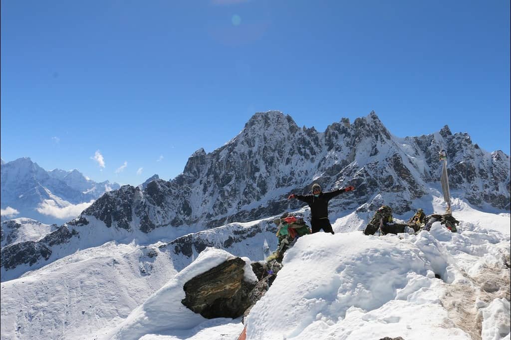
Day 12 : CHHUKUNG → CHHUKUNG RI (5,550 M / 18,209 FT) → CHHUKUNG
Day 13 : CHHUKUNG → KONGMA LA (5,535 M / 18,159 FT) → LOBUCHE (4,940 M / 16,207 FT)
Day 14 : REST & ACTIVE RECOVERY — LOBUCHE (4,940 M / 16,207 FT)
Day 15 : LOBUCHE → GORAK SHEP (5,160 M / 16,929 FT) + KALA PATAR (5,554 M / 18,222 FT)
Day 16 : TREK TO EVEREST BASE CAMP (5,300/ 17,400) FOR LUNCH, THEN DESCEND TO LOBUCHE
Day 17 : LOBUCHE → DZONGLA (4,830 M / 15,846 FT)
Day 18 : DZONGLA → CHO LA (5,420 M / 17,780 FT) → DRAGNAG/THANGNAK (4,700 M / 15,420 FT)
Day 19 : TREK TO GOKYO (4,790 / 15,715) — CROSSING THE NGOZUMPA GLACIER TO THE TURQUOISE LAKES
Day 20 : REST IN GOKYO OR CLIMB GOKYO RI (5,357 M / 17,575 FT)
Day 21 : GOKYO → RENJO LA (5,465 M / 17,930 FT) → LUNGDEN/LUMDE (≈4,380 M / 14,370 FT)
Day 22 : LUNGDEN/LUMDE → THAME (3,844 M / 12,612 FT)
Day 23 : THAME → NAMCHE BAZAAR (3,440 M / 11,286 FT)
Day 24 : NAMCHE BAZAAR → LUKLA (2,860 M / 9,383 FT)
Day 25 : CONTINGENCY / BUFFER DAY
Day 26 : LUKLA → RAMECHHAP (MANTHALI) FLIGHT, THEN DRIVE TO KATHMANDU
Day 27 : FINAL DEPARTURE — KATHMANDU → HOME
Make your own way to NEW YORK for your scheduled flight to Kathmandu (KTM). Most routings are via one stop (e.g., Middle East/South Asia). Check in, clear security and settle in for the overnight journey.
Travel notes:
Practical notes:
Today’s quick facts:
Touch down at Tribhuvan International Airport (KTM). After clearing formalities, meet our representative just outside the arrivals hall for your private transfer to the hotel. Check in, refresh, and enjoy the rest of the day at leisure.
Heads-up: Your greeter will hold a company sign at the main exit. If you can’t locate them, stay inside the arrivals area and call the emergency number on your voucher—don’t accept unsolicited rides.
Light suggestions (easy & flexible):
Travel notes:
Heads-up: Thamel can be busy and noisy—earplugs help for light sleepers. Air can be dusty in dry months; a light mask and sunglasses are handy for strolls.
Practical notes:
Today’s quick facts:
A practical prep day in Kathmandu. After breakfast, meet your leader for a detailed briefing on the trek and Island Peak approach: daily stages, acclimatisation strategy, summit timings, and safety protocols. We’ll complete a thorough equipment inspection, confirm permits/admin, and finalise any hire items. The remainder of the day is kept flexible for last-minute shopping and light exploring.
Heads-up: Your travel insurance must explicitly cover high altitude trekking/climbing to ~6,200 m and helicopter evacuation. Keep passport + 2 photos handy for permits and any gear hire paperwork.
Gear checklist (spot-check & fitting):
Hire options are available locally (subject to sizes/stock). We’ll reserve any gaps during the check.
Planning & admin:
Heads-up: Thamel shops often take cards with a surcharge; cash can be faster. Try on hire boots with your own socks and walk a few minutes; photograph rental items and keep the receipt.
If time permits (easy options):
Today’s quick facts:
Set out from your hotel around 03:00 for the road journey (approx. 4–5 hrs) to Ramechhap/Manthali Airport (RHP), where most mountain flights operate. Your packed breakfast travels with you. On arrival, check in for the short hop (about 20–25 mins) to Lukla, gateway to the Khumbu. Meet the porter team, adjust daypacks, and step onto the trail.
Heads-up: Mountain flights are weather-dependent and may stagger through the morning. Keep warm layers, snacks, and patience handy; your leader will manage any timing changes.
Flight & luggage notes:
From Lukla, the path slips off the airstrip ridge and joins the Dudh Koshi valley. Walk past stone-walled hamlets such as Chheplung and Ghat, spin prayer wheels (clockwise), and cross the first suspension bridges. With a gentle net descent, today’s pace is unhurried—perfect for easing into altitude—ending at the riverside village of Phakding.
Heads-up: Give way to yak/mule trains from the mountain side; pass mani walls on the left. Keep a relaxed, conversational pace and sip water regularly.
Trek facts
Practical notes: Sun can be strong even on cool days—use high-SPF and glacier-grade sunglasses. Keep rain shell accessible; weather shifts quickly in the valley.
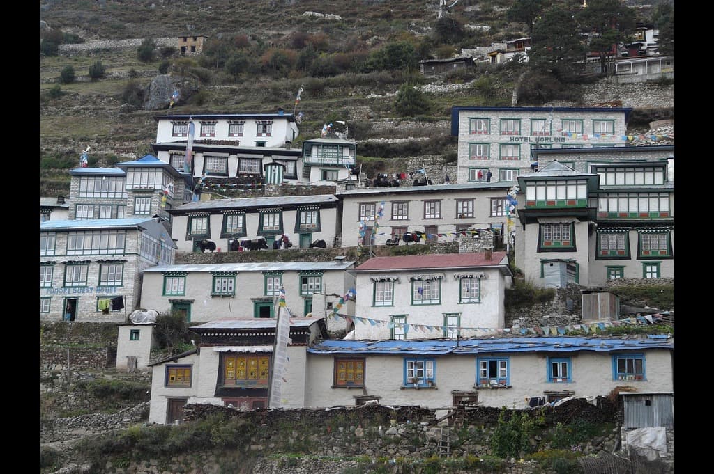
Follow the Dudh Koshi upstream through stone-walled hamlets toward Monjo, gateway to Sagarmatha National Park. After ticketing, continue to Jorsalle for a short break, then tackle the sustained climb to Namche Bazaar, crossing the iconic Hillary Bridge high above the river and zigzagging through pine and rhododendron forest to the amphitheatre town.
Heads-up: Keep passport & permits handy for the Monjo checkpoint. The Hillary Bridge is exposed—secure hats/sunglasses and give way to pack animals from the mountain side.
Route notes:
Acclimatisation & health:
Heads-up: Pass mani walls on the left and spin prayer wheels clockwise. Step aside early for yak/mule trains and avoid sudden movements.
Today’s quick facts
Practical tip: Keep a warm layer accessible—shade in the forest can feel cool after the river sections.
A gentle day in Namche Bazaar (3,440 m / 11,286 ft) to help your body adapt. Keep activity light and steady—short hikes, easy browsing in town, lots of fluids and an early night.
Heads-up: Follow “climb high, sleep low.” Walk slowly, sip water regularly, use electrolytes, and avoid alcohol today. Report unusual headache, nausea or dizziness to your leader immediately.
Light acclimatisation ideas (choose one):
Aim for 2–4 hrs total on feet, keeping effort easy; turn back early if you feel off-pace.
Easy things to do in town:
Heads-up: UV is strong at altitude—use high-SPF sunscreen and glacier sunglasses. On paths, keep to the mountain side when pack animals pass; go around mani walls on the left.
Today’s quick facts
Climb out of Namche on a balcony trail, passing the Syangboche airstrip and up to the classic Hillary View Point / Everest View area (~3,850–3,880 m) for sweeping looks to Ama Dablam, Lhotse and (weather permitting) Everest. Continue gently over stone-walled terraces to the broad Sherpa village of Khumjung beneath Khumbila.
Heads-up: This is an acclimatisation gain day—walk at a conversational pace, sip water often, and use high-SPF sunscreen & glacier sunglasses on the exposed ridge.
Route notes:
Optional add-on (time & energy permitting):
Heads-up: Weather can change quickly on the ridge—keep a windproof shell and warm gloves handy on top of your pack.
Today’s quick facts
Practical tip: If you feel headachy or unusually fatigued at the viewpoint, descend to Khumjung without delay and rest—sleeping lower helps.
Leave Khumjung on a pleasant contour towards Kyangjuma/Sanasa, with wide views to Ama Dablam and the Everest–Lhotse wall. From the ridge the trail drops on stone steps through pine and rhododendron to the riverside hamlet of Phunki Tenga. After a tea stop, tackle the steady forest climb to the prayer-flagged saddle of Tengboche, home to the region’s famous monastery and a superb mountain amphitheatre.
Heads-up: Visiting Tengboche Monastery? Dress modestly, remove hats and sunglasses inside, speak softly, and carry small cash for donations. Drones are not permitted.
Route notes:
Heads-up: The post-lunch climb from Phunki Tenga is sustained—pace at a conversational rhythm, sip water regularly, and use electrolytes. UV is strong on the ridge even in cool air.
Today’s quick facts
Practical tip: Afternoon clouds and breeze are common—arrive early for clearer views and keep a windproof layer on top of your pack.
Step off the Tengboche ridge and drift through the quiet woods of Deboche before crossing the Imja Khola. The trail then rises on open slopes to Pangboche and the yak pastures around Shomare. Here the valley widens and the path divides: bear left for Pheriche (windswept, slightly lower) or right for Dingboche (sunnier terraces a little higher).
Heads-up: Pick your overnight with acclimatisation in mind. Pheriche sleeps lower and often feels easier. Dingboche is higher but sunny and convenient for tomorrow’s acclimatisation walk. Tell your leader how you’re feeling before committing.
Route notes:
Health & acclimatisation:
Optional en-route:
Today’s quick facts
Practical tip: Afternoon valley winds are common—add a windproof layer before the exposed sections beyond Shomare.
Keep activity light and purposeful to help your body adapt. The aim is “climb high, sleep low”: gain a few hundred metres gently, spend a short time at your high point, then return to your lodge to rest, hydrate and eat well.
Heads-up: Walk at a conversational pace, sip water frequently (add electrolytes), use high-SPF sunscreen & glacier sunglasses, and avoid alcohol. Report headache, nausea, dizziness or unusual fatigue to your leader immediately.
If in Dingboche (4,410 m): suggested walks
If in Pheriche (4,270 m): suggested walks
Easy things to do (either village):
Heads-up: Afternoon winds are common—carry a windproof shell, warm hat & gloves. On paths, pass mani walls on the left and give way to pack animals from the mountain side.
Today’s quick facts
Practical tip: Lay out tomorrow’s layers, poles, head torch and snacks this evening for a smooth start.
Ease up the broad Imja Valley from Dingboche (or link across from Pheriche via the valley floor) on stone-walled terraces and yak pasture. The path rises gently past chortens and summer shelters at Bibre, with ever-bigger views to Ama Dablam, the Lhotse wall and the Imja Glacier, before a final mellow approach into the small lodge cluster of Chhukung.
Heads-up: Afternoon valley winds are common—add a windproof shell and warm gloves. UV is strong at altitude: use high-SPF sunscreen and glacier sunglasses even on cool days.
Route notes:
Optional (time & energy permitting): short acclimatisation stroll above Chhukung
Heads-up: Pace at a conversational rhythm and sip water regularly (electrolytes help). Report headache, nausea or dizziness to your leader promptly.
Today’s quick facts
Practical tip: On arrival, sort/label technical kit for upcoming skills and pass checks (helmet, harness, jumar, crampons, head torch).
Set out from Chhukung (4,730 m) on a steep, well-trodden ridge towards the rocky tops of Chhukung Ri. The path climbs quickly on gravel and stone steps, easing over occasional benches before a final push to the prayer-flagged summit for vast views to Lhotse, Makalu, Ama Dablam and the Imja Glacier/Lake. After photos and a short rest, descend the same way to sleep low in Chhukung.
Heads-up: Agree a firm turn-around time. If wind, cloud or fatigue build, it’s fine to turn at the lower shoulder (~5,100–5,300 m) and still achieve excellent acclimatisation.
Route notes:
Safety & pacing:
Optional:
Today’s quick facts
Practical tip: Pack a warm drink and a light puffy in the top of your daypack—summit breezes can be sharp even on sunny days.
A big alpine traverse linking the Imja and Khumbu valleys. Leave Chhukung (4,730 m) pre-dawn, climbing moraine ribs and scree benches toward the prayer-flagged Kongma La. Vast views open to Lhotse, Nuptse and Ama Dablam. From the col, descend carefully on loose gravel past turquoise tarns into the upper Khumbu basin, then pick up cairns across the rubbly margin of the Khumbu Glacier to reach the lodges at Lobuche.
Heads-up: There are no teahouses between Chhukung and Lobuche via the pass. Carry at least 1.5–2 L of water, a packed lunch, and sufficient warm layers. Agree a firm turn-around time with your leader.
Route notes:
Heads-up: Expect strong ridge winds and high UV. Layer a windproof shell, warm hat & gloves; use glacier sunglasses and high-SPF sunscreen. Pace at a conversational rhythm and sip water regularly (electrolytes help).
Recommended to carry today:
Safety & acclimatisation:
Today’s quick facts
Practical tip: Pre-pack extra layers and snacks handy near the top of your pack—weather flips fast on the pass.
A purposeful pause to consolidate altitude gains after Kongma La. Keep movement gentle, hydrate well, and prioritise food and sleep. The aim is light activity to stimulate acclimatisation without adding meaningful fatigue.
Heads-up: Walk at a conversational pace, sip water regularly (electrolytes help), use glacier sunglasses & high-SPF sunscreen, and avoid alcohol. Report headache, nausea, dizziness or unusual fatigue to your leader immediately.
Suggested easy outings (choose one):
In-lodge recovery:
Heads-up: Winds can rise quickly—carry a windproof shell, warm hat & gloves even for short strolls. Keep to the mountain side when pack animals pass and go left of mani walls.
Today’s quick facts
Practical tip: Pre-pack tomorrow’s day bag (1–1.5 L water, snacks, shell, warm layers, head torch) for a smooth early start.
From Lobuche, follow the undulating lateral moraine above the Khumbu Glacier, weaving across gravel benches and short rocky steps to reach the high settlement of Gorak Shep beneath the dark hump of Kala Patar. After hot drinks and a light meal, shoulder daypacks for the afternoon push to the summit ridge—your closest, most dramatic viewpoint of the Everest–Lhotse–Nuptse wall.
Heads-up: Choose sunset (carry a head torch for the descent) or first light tomorrow if energy or weather suggest delaying. Agree a firm turn-around time either way.
Route notes:
Heads-up: Thin air and gusty winds are normal here. Layer a windproof shell, warm hat & gloves; use glacier sunglasses and high-SPF sunscreen. Pace at a conversational rhythm and sip water regularly (electrolytes help).
Safety & health:
Carry this afternoon:
Today’s quick facts
Practical tip: Keep a warm layer handy at the top of your pack—temperatures drop fast near the summit, even on sunny afternoons.
Set out from Gorak Shep (5,160 m) along the rim of the Khumbu Glacier, following a rolling moraine path to the cairn-marked flats of Everest Base Camp. Enjoy photo time by the prayer-flagged markers and pause for a packed lunch amid the ice-serac scenery. Retrace to Gorak Shep for a warm drink, then continue back down the lateral moraine to Lobuche (4,940 m) for the night.
Heads-up: There are no teahouses at EBC—today’s lunch is packed. Stay on the marked trail and do not venture onto the icefall or fresh glacier ice.
Route notes:
Heads-up: Thin air, strong UV and gusty winds are common—carry a windproof shell, warm hat/gloves, glacier sunglasses and high-SPF sunscreen. Pace at a conversational rhythm and sip water regularly (electrolytes help).
Practical tips:
Today’s quick facts
Leave Lobuche (4,940 m) and contour on a quieter balcony path with big views to Taboche and Cholatse. The trail rolls over gravel benches, dips to cross streams, then climbs gently above the turquoise Chola Tsho before a final short rise into the yak-pasture hamlet of Dzongla, poised beneath the dramatic north wall of Cholatse.
Heads-up: Expect narrow traverses with some exposure above the lake. Step to the mountain side for yak/mule trains and let them pass. Winds can funnel in the afternoon—keep a shell handy.
Route notes:
Practical & safety tips:
Today’s quick facts
Practical tip: Dzongla is the staging point for the Cho La crossing—sort layers, head torch and snacks tonight for an efficient alpine start tomorrow.
A classic high pass linking the Khumbu and Gokyo valleys. Leave Dzongla (4,830 m) pre-dawn, climbing steadily on moraine and rock slabs into a narrowing amphitheatre. The final pull to the prayer-flagged Cho La is steep and can be icy. Beyond the col, a short traverse over the Cho La glacier leads to boulder fields and a long descent into the broad basin above Dragnag/Thangnak.
Heads-up: There are no teahouses between Dzongla and Dragnag via Cho La. Carry at least 1.5–2 L of water, a packed lunch, and sufficient warm layers. Agree a firm turn-around time.
Heads-up: Expect icy slabs, loose scree and occasional rockfall zones near the pass. Keep helmets available if advised, maintain spacing on the glacier, and follow cairns/guide instructions closely.
Route notes:
Safety & pacing:
Recommended to carry today:
Today’s quick facts
Practical tip: Pack spikes and warm layers near the top of your bag—you may need them suddenly on the upper slabs or glacier.
From Dragnag/Thangnak (≈4,700 m), a short but intricate stage leads across the undulating Ngozumpa Glacier to the lakeside hamlet of Gokyo beside Dudh Pokhari (Third Lake). Expect steady ups and downs over gravel, boulders and sandy troughs before the final rise to the moraine crest and a gentle roll into the village.
Heads-up: The glacier route changes season-to-season. Follow your guide, cairns and wands closely; do not stray onto blue ice or near unstable moraine edges.
Route notes:
Practical & safety tips:
On arrival in Gokyo (time permitting):
Today’s quick facts
Practical tip: Keep electronics warm in inner pockets—cold air around the lakes drains batteries fast.
Keep today flexible. If recovery is the priority, enjoy a relaxed lake-side day in Gokyo (4,790 m). If energy and weather align, tackle the classic out-and-back hike up Gokyo Ri for sweeping views of Everest, Lhotse, Makalu and the turquoise Gokyo Lakes. Many trekkers favour a late-afternoon ascent for golden light and a dramatic sunset—then descend by head torch.
Heads-up: For a sunset summit, carry a head torch and set a clear turn-around time. Temperatures drop quickly after 15:00—layer up before the ridge.
If climbing Gokyo Ri — route notes:
If resting — easy options:
Health & acclimatisation:
Carry for the Gokyo Ri option:
Today’s quick facts
Practical tip: Keep electronics in inner pockets—cold wind on the summit ridge drains batteries fast.
Follow the north shore of Dudh Pokhari from Gokyo (4,790 m) before climbing long, steady switchbacks to the prayer-flagged crest of Renjo La. The pass serves up one of the finest panoramas in the Khumbu—Everest, Lhotse, Nuptse, Makalu and Cho Oyu on a blue-sky day. From the col, descend on stone steps and scree past turquoise tarns into the Bhote Koshi valley, easing at last to the quiet hamlet of Lungden/Lumde (≈4,380 m).
Heads-up: No services between Gokyo and Lungden via Renjo La—carry 1.5–2 L water, a packed lunch, and warm layers. Set a firm turn-around time if weather shifts.
Heads-up: Upper slopes can be icy early/late season; winds funnel at the col. Keep a shell and spare gloves accessible; microspikes may be advised by your leader.
Route notes:
Practical & safety tips:
Carry today:
Today’s quick facts
Practical tip: Keep electronics in inner pockets—cold, dry air on the pass drains batteries quickly.
Leave Lungden/Lumde (≈4,380 m) and descend the broad Bhote Koshi valley on good trails. The route passes small hamlets (e.g., Marulung) and terraced yak pastures with wide views to rugged trade-route ridges that lead toward the Nangpa La. Stone steps and easy riverside sections guide you to the tranquil Sherpa village of Thame, one of the oldest settlements in the Khumbu.
Heads-up: Afternoon winds can funnel down the valley—keep a windproof layer handy. When passing yak/mule trains, stand on the mountain side and give animals space.
Route notes:
Practical & safety tips:
On arrival in Thame (time permitting):
Today’s quick facts
Practical tip: Air and reorganise gear this afternoon—tomorrow’s trek trends lower and warmer.
Leave Thame (3,844 m) on a mellow valley path beside the Bhote Koshi, passing stone walls, chortens and small hamlets such as Marulung and Thamo. The trail then contours on a pleasant balcony track before rounding into the natural amphitheatre of Namche Bazaar, with cafés, bakeries and gear shops signalling a welcome return to bustle and lower air.
Heads-up: You’ll share the path with yak/mule trains—stand on the mountain side and let animals pass. Afternoon winds can funnel down-valley; keep a windproof layer handy.
Route notes:
Practical tips & on arrival:
Today’s quick facts
Practical tip: If your visit falls on a Saturday, the weekly market in Namche is lively in the morning.
Bid farewell to Namche Bazaar (3,440 m) and wind down through pine and rhododendron to the Hillary Bridge. Follow the Dudh Koshi past Jorsalle and the park gate at Monjo, then continue through Benkar, Phakding and Ghat/Chheplung. A steady final ascent leads back up to Lukla’s airstrip ridge—time to celebrate the close of your trek.
Heads-up: You’ll exit Sagarmatha National Park at Monjo—keep permits and passport accessible for inspection.
Heads-up: Prepare for tomorrow’s mountain flight. Typical allowance is ~10 kg checked + 5 kg hand (airline-dependent). Sort/label your duffel this evening.
Route notes:
Practical & pacing tips:
On arrival in Lukla:
Today’s quick facts
Practical tip: Keep your head torch handy—Lukla power can be intermittent in the evening.
This day is kept flexible to absorb weather-related delays—most commonly affecting the Lukla ⇄ Ramechhap (Manthali) flights—or to provide additional rest and recovery after the trek. Your leader will confirm the plan the evening before based on the latest conditions and airline updates.
Heads-up: Mountain flight schedules can change at short notice. Typical allowance is ~10 kg checked + 5 kg hand (airline-dependent). Keep passport, permits, warm layer, water and snacks in your daypack.
Heads-up: Stay close to the airstrip/lobby when on standby—boarding calls can be rapid when a weather window opens.
If you are still in Lukla:
If you have flown to Ramechhap (Manthali):
If you are already in Kathmandu:
Health & admin:
Today’s quick facts
Practical tip: Keep a head torch handy—power can be intermittent in Lukla and during early check-ins.
Check in early at Lukla for the short mountain hop to Ramechhap (Manthali). On clear mornings, the flight traces ridgelines and the Dudh Koshi valley. On landing, meet your vehicle and continue by road through mid-hills and river valleys back to Kathmandu, usually arriving late afternoon/early evening depending on traffic and road conditions.
Heads-up: Mountain flights are weather-dependent and timings can shift. Typical allowance is about
10 kg checked + 5 kg hand (airline policy dependent). Keep passport, permits, warm layer, snacks and water in your daypack.
Heads-up: Be ready for standby calls if a weather window opens.
Power can be intermittent in Lukla—charge devices the night before and carry a power bank.
Flight notes (Lukla → Ramechhap):
Drive Ramechhap → Kathmandu:
Practical tips:
Today’s quick facts
Tip: Keep a small pouch accessible with passport, permits, snacks, water and hand sanitiser to streamline airport and road transitions.
Enjoy a relaxed breakfast at the hotel if time permits, then meet your driver for your
airport transfer to Kathmandu (KTM). Allow generous time for city traffic and
international check-in. Safe journey and dhanyabad!
Heads-up: Plan to arrive at the airport ~3 hours before your international flight. Keep passport, e-ticket, and any required travel documents handy in your carry-on.
Heads-up: Power banks and lithium batteries must go in hand luggage.
Observe standard liquids rules for security. Keep valuables and electronics with you.
Practical notes:
Today’s quick facts
Tip: Wear/pack a light layer for cool aircraft cabins; keep medications in your carry-on.
| Start Date | End Date | Price | Note | AVAILABILITY | Booking |
|---|---|---|---|---|---|
| Mon, 5 Oct, 26 | Sat, 31 Oct, 26 | $9362 | GUARANTEED | Book Now | |
| Sun, 1 Nov, 26 | Fri, 27 Nov, 26 | $9362 | GUARANTEED | Book Now | |
| Mon, 1 Mar, 27 | Sat, 27 Mar, 27 | $9898 | GUARANTEED | Book Now | |
| Mon, 5 Apr, 27 | Sat, 1 May, 27 | $9898 | GUARANTEED | Book Now | |
| Mon, 3 May, 27 | Sat, 29 May, 27 | $9898 | GUARANTEED | Book Now | |
| Mon, 4 Oct, 27 | Sat, 30 Oct, 27 | $9898 | GUARANTEED | Book Now |
A blend of a comfortable city hotel (pre/post trek) and best-available teahouse lodges throughout the Khumbu, plus simple high-altitude stops near the passes. Teahouses are family-run with twin rooms (basic bedding), shared bathrooms (occasional en-suite at lower altitudes), hearty home cooking, and heated dining rooms. Heating in bedrooms is limited; hot showers, device charging and Wi-Fi (where available) are usually paid locally.
| Place | Accommodation / Description |
| Kathmandu (pre-trek) | Well-located hotel (e.g., Thamel area) with en-suite rooms, breakfast, luggage storage; ideal for trek prep. |
| Phakding | Riverside teahouse (best available); simple twin rooms, warm dining hall, paid hot shower/charging. |
| Namche Bazaar | Central teahouse; bakery/cafés nearby; shared bathrooms common, occasional en-suite rooms at extra cost. |
| Khumjung / Kunde | Village teahouse; quieter Sherpa heartland with wide valley views; basic comforts, homestyle meals. |
| Tengboche / Deboche | Monastery-ridge/forest teahouses; spectacular mountain skyline; limited facilities in peak season. |
| Dingboche or Pheriche | High-altitude teahouse (best available); windy afternoons; paid Wi-Fi/charging common. |
| Chhukung | Small settlement teahouses near Imja valley; gateway for Chhukung Ri and Kongma La. |
| Lobuche | High-altitude teahouse; simple rooms, busy in season; limited water, very basic bathrooms. |
| Gorak Shep | Final outpost near EBC/Kala Patar; very basic accommodation; warm dining area, plumbing often frozen. |
| Dzongla | Small, scenic teahouse above Cho La approach; simple rooms, early starts typical. |
| Dragnag (Thangnak) | Glacier-side teahouse beneath Cho La; basic comforts; can be cold/windy. |
| Gokyo | Lakeside teahouse with superb views; access to Gokyo Ri; paid showers/charging when power allows. |
| Lungden | Quiet hamlet teahouse near Renjo La approach; very simple rooms; early breakfast for pass days. |
| Thame | Traditional Sherpa village teahouse; calmer pace, cultural interest, basic facilities. |
| Lukla | Teahouse near airstrip; convenient for early flights; intermittent power/Wi-Fi. |
| Kathmandu (post-trek) | Comfortable hotel with hot showers, laundry (chargeable) and easy access to dining/shopping. |
Heads-up: At altitude, hot showers, device charging and Wi-Fi are often paid locally and may be unavailable during busy or cold periods. Carry a power bank and keep batteries warm.
Heads-up: You may be asked to show proof of insurance at briefing. Without suitable cover, you may be unable to join the trek/climb.
Safety & Risk Notice: High-altitude trekking involves inherent risk (altitude illness, weather, terrain). By joining, you acknowledge and accept these risks and agree to follow your leader’s instructions.
Participation is voluntary and at your own risk. As part of pre-departure documents, you will be asked to sign a risk acknowledgement/waiver confirming you understand the hazards associated with altitude, remote environments, weather and logistics, and that suitable insurance is in place.
Air Safety Context: Domestic mountain flights in Nepal are operated by local Nepal-based carriers. The EU Air Safety List currently includes all Nepali airlines, which means they cannot operate within EU airspace. This does not prevent domestic operations inside Nepal, but services are subject to local regulation and weather/terrain constraints.


Embark on an Unforgettable Journey Across Nepal and India – The…
Embark on an unforgettable 12-day round-trip through central Nepal, where…
You will explore Nepalese culture, heritage, wildlife, adventure with…


Our team is at your service to help you with your booking issues or answer any related questions
1-888-214-4856
Start planning your tailor-made holiday by contacting one of our specialists of Nepal
call our specialists on
1-888-214-4856
Written by our travel specialists, our brochures highlight the incredible places you can explore and help simplify the choices when planning your trip. Whether you’re ready to enquire or just gathering ideas, we’re here to support you.
Our customers praise our staff’s professionalism and the world-class service we consistently provide.
ATOL and ABOT protected company. Plus, a refund within 14 days if your holiday is cancelled.
Our specialists have in-depth knowledge from extensive travel or living in the regions they manage.
Our prices are unmatched. Find a better deal, and we’ll refund the difference within 24 hours.
 Nepal
Nepal Singapore
 Taiwan
 India
India Bhutan
 Tibet
Tibet China
China Sri Lanka
 Thailand
 Cambodia
 Vietnam
 Laos
Laos Japan
Japan South Korea
 Maldives
 Malaysia
 Indonesia
 Philippines
 Mongolia
 Uzbekistan
 Ethiopia
 Kenya
Kenya Madagascar
 Mauritius
 Morocco
 Namibia
 Rwanda
 South Africa
 Tanzania
 Tunisia
 Uganda
 Zimbabwe
 Egypt
Egypt Jordan
 Oman
Oman Saudi Arabia
 United Arab Emirates
 Armenia
 Bulgaria
 Croatia
 Cyprus
 Czech Republic
 France
 Greece
 Iceland
 Ireland
 Italy
Italy Malta
Malta Portugal
 Romania
 Slovenia
 Spain
Spain Turkey
 America
 Belize
 Canada
 Costa Rica
 Guatemala
 Mexico
 Panama
 Argentina
 Brazil
 Chile
Chile Colombia
 Ecuador
 Peru
Peru Australia
 French Polynesia
 New Zealand