-

- Home
- Company
- Destinations
- Activities
- Essential Info
- News
- Contact


17 days from $4681 pp with roundtrip flights
The Naar Phu Valley Trek threads into two of Nepal’s most secluded valleys, where cliff-cut trails, stone villages and Tibetan culture meet stark high-desert scenery. You’ll pass mani walls, chortens and the storied Phu Gate before entering a cluster of centuries-old homes perched above the Phu Khola.
The route arcs Kathmandu → Jagat → Dharapani → Koto (permit checkpoint), then leaves the busy circuit for the wild gorge to Meta, Kyang and Phu (4,080m). Returning via Upper Chyako, you climb to Naar (4,110m), stage an acclimatisation hike toward Kangla Phedi, then make a pre-dawn push over the panoramic Kang La Pass (5,306m) to ridge-top Ngawal. Rejoining the Annapurna Circuit, descend past the sweeping rock face of Paungda Danda to Chame and out by road to Besisahar.
Trails are mostly firm dirt, stone steps and occasional scree with airy balcony sections. No technical climbing is required, but the Kang La day is long and high. This is a lodge-based itinerary (no camping) designed around smart acclimatisation.
At a glance:
• Duration: ~17 days total • Trekking days: ~10–11
• Max altitude: 5,306m (Kang La) • Highest sleep: Naar 4,110m
• Difficulty: Moderate–strenuous (one very big pass day)
• Style: Lodge/teahouse throughout (no high camp)
• Best season: Mar–May & Sep–Nov
Permits & logistics: Naar–Phu Restricted Area Permit (RAP) and ACAP required; registration at Koto. Carry your original passport, two photos, and travel insurance covering trekking/evacuation. Ethical porter loads (~15 kg client duffel) and lodge availability shape daily distances.
Signature highlights: Phu Gate & hill-fort ruins • Living Tibetan Buddhist culture in Phu & Naar • Wild gorge paths above the Phu Khola • Summit panorama from Kang La to Annapurna II, Gangapurna & Tilicho Peak • The stone wave of Paungda Danda • Big-sky desert moraines and yak pastures.
Who it’s for: Fit hikers seeking remote valleys, authentic culture and one high, committing pass day—comfortable with simple teahouses, sustained time at 3,500–4,100m, and early starts for optimal conditions.
Day 1 : DEPART NEW YORK → KATHMANDU
Day 2 : ARRIVAL KATHMANDU
Day 3 : KATHMANDU → JAGAT (1,300M) — ROAD APPROACH INTO THE MARSYANGDI VALLEY
Day 4 : JAGAT → CHAMJE → TAL → DHARAPANI (1,860M)
Day 5 : DHARAPANI → BAGAR CHAP → KOTO (2,600M) — BALCONY PATHS & MANASLU VIEWS
Day 6 : KOTO CHECKPOINT → NAAR PHU KHOLA GORGE LODGE (≈3,000M)
Day 7 : NAAR PHU KHOLA GORGE → META (3,560M)
Day 8 : META → CHYAKO → KYANG (3,800M)
Day 9 : KYANG → PHU (4,080M) — GORGE BALCONIES, PHU GATE & HILL-FORT SKYLINE
Day 10 : PHU → KYANG → UPPER CHYAKO (3,600M)
Day 11 : UPPER CHYAKO → NAAR PHEDI BRIDGE → NAAR (4,110M)
Day 12 : NAAR — ACCLIMATISATION HIKE TOWARDS KANGLA PHEDI (RETURN TO NAAR LODGE)
Day 13 : NAAR (4,110M) → KANG LA (5,306M) → NGAWAL (3,660M)
Day 14 : NGAWAL → PISANG → CHAME — REJOIN THE ANNAPURNA CIRCUIT
Day 15 : CHAME → TIMANG (TREK) → BESISAHAR (4WD TRANSFER)
Day 16 : BESISAHAR → KATHMANDU — VALLEY DRIVE & HOTEL CHECK-IN
Day 17 : DEPART KATHMANDU
Your journey to the wild valleys of Naar and Phu begins at NEW YORK. Arrive around 3 hours before departure for your long-haul NEW YORK to Kathmandu flight—the opening chapter of an unforgettable Naar Phu Trek through fortress-like villages, yak pastures and high passes.
Flight note: Most routings are a convenient one-stop connection. Check your baggage allowance in the airline app. Pack trekking poles, liquids and multi-tools in checked baggage; keep power banks, valuables and meds in your carry-on.
After security, choose a light meal, hydrate and stretch. On board, sip water regularly, take brief aisle walks and keep caffeine/alcohol modest to arrive fresher. A neck pillow, eye mask and earphones help with rest on the overnight sector to Kathmandu (KTM).
Permits & paperwork (Naar Phu): We arrange your required permits, including the Restricted Area Permit for Naar–Phu and ACAP. Please carry your original passport (no scans), at least 2 passport photos, and your travel insurance details covering trekking/altitude.
Time-zone tip: Set your watch to Nepal Standard Time (UTC+5:45) after take-off to ease the body-clock shift. Keep your airline app open for live gate updates and baggage details.
As cabin lights dim and stars arc beyond the wing, London’s glow fades to cloud-soft hush. Tomorrow you’ll descend into the Kathmandu Valley—your gateway to permit formalities, gear checks and the remote trails that lead towards Naar and Phu.
Flight summary: NEW YORK → Kathmandu (KTM), overnight sector; airline, flight numbers and timings as per ticket.
Touch down at Tribhuvan International Airport (KTM) and breathe in your first notes of the Himalaya. After immigration and baggage claim, meet our representative for a private transfer to your hotel. The remainder of the day is at leisure—unwind, freshen up and ease gently into the valley’s rhythm ahead of your Naar Phu briefing and permit formalities.
Arrival & visa: Many nationalities are eligible for eVisa/visa on arrival. Keep your passport (6+ months validity), one passport photo, hotel address and the visa fee ready. Complete the arrival form → visa counter (if applicable) → passport control → baggage.
Private transfer: Our staff will greet you with a nameboard in the arrivals hall and escort you to your vehicle. The drive offers first glimpses of temple spires, prayer wheels and the daily buzz of Kathmandu.
Permits & paperwork (today): We arrange your Restricted Area Permit (RAP) for Naar–Phu and ACAP. Please keep your original passport, at least 2 passport photos, and insurance details handy for the morning briefing and applications.
Health & acclimatisation: Kathmandu sits ~1,400m. Hydrate well, keep meals light and avoid strenuous activity or alcohol. An early night helps you adjust before heading towards the Marshyangdi valley and the high trails to Naar and Phu.
Light exploring (optional): A gentle stroll in Thamel for last-minute kit, or a quiet hour in the Garden of Dreams. Save the big heritage sites for after the trek or a guided city tour.
Money & mobile: Currency is NPR. ATMs and authorised exchangers are available in the airport and city. Consider a local SIM (passport required) for data/calls; Wi-Fi is common in city hotels.
Today at a glance: Arrive KTM → Immigration & baggage → Meet & greet → Private hotel transfer → Leisure (optional short walk) → Early night for Naar Phu briefing & permits tomorrow.
After breakfast, depart Kathmandu west along the Prithvi Highway, bound for the trailhead of the Naar Phu Trek. The road threads terraced hillsides and river gorges before reaching Mugling, where we pause for an early lunch at a simple roadside café. Back on the move, we pass Dumre and swing north beside the Marsyangdi River, trading highways for a narrower valley road and ever-closer views of Middle Hills ridgelines. A long suspension span at Syange carries us across the river; from here a short climb winds up to the stone lanes of Jagat (1,300m) for tonight’s stay.
Route & timing: Kathmandu → Mugling (early lunch) → Dumre → Syange bridge → Jagat. Allow roughly 6–8 hours total driving time, depending on traffic, roadworks and weather.
Road & safety: Expect mixed surfaces (tarmac, graded gravel) and occasional rough patches or delays. Wear seatbelts, keep valuables in your daypack, and carry water and motion-sickness tablets if needed.
Permits & formalities: The ACAP entry and local posts are encountered in this corridor; keep your passport, permits and a couple of passport photos accessible for checks.
Luggage: Your trek duffel travels with the support vehicle/crew; keep essentials (water, snacks, jacket, meds, documents) in your daypack. Charging and reliable Wi-Fi become limited beyond today—top up devices in Kathmandu.
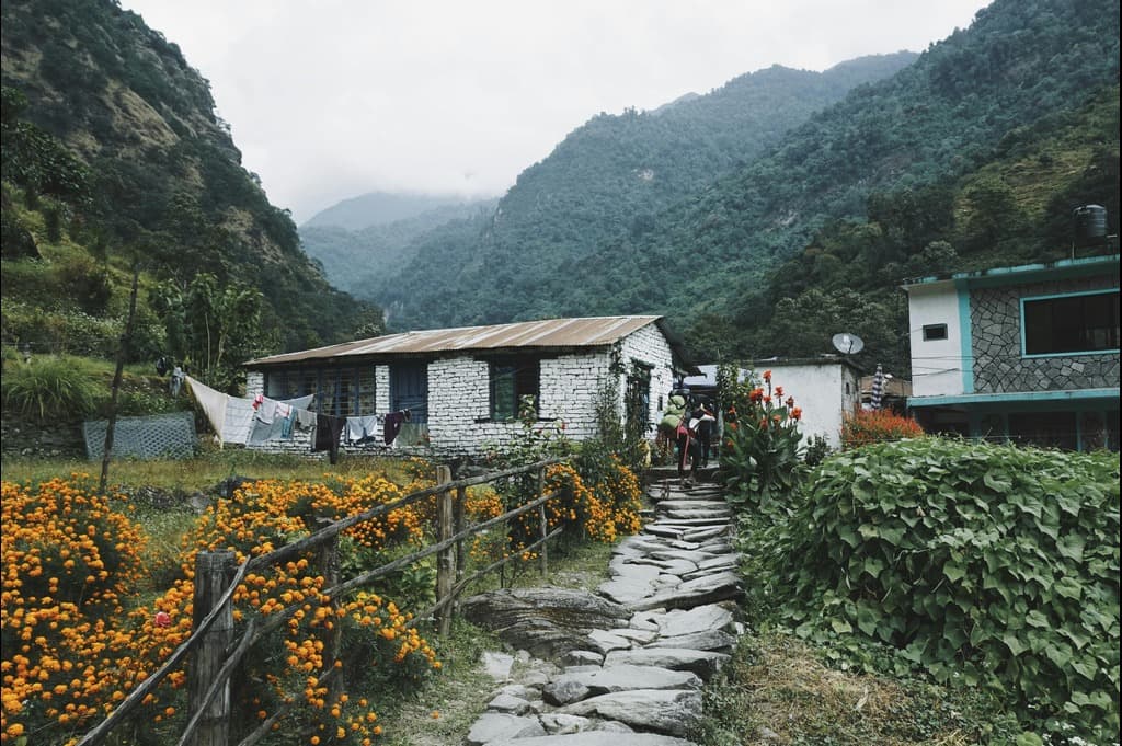
First night on the route: Jagat offers basic teahouse lodgings with twin rooms and shared facilities. An early dinner and good rest set you up for tomorrow’s first walking stage towards the higher villages of the Marsyangdi.
Today at a glance: Drive Kathmandu → Jagat via Mugling & Dumre • Cross the Marsyangdi at Syange • Arrive Jagat (1,300m) • Overnight in teahouse.
Boots on for our first walking day. Leaving Jagat, we gain height on a steady riverside path towards Chamje, keeping to the older foot-trail wherever it peels away from the rough jeep track. A short descent leads to a suspension bridge crossing of the Marsyangdi, then the trail climbs through pine and rock terraces to the broad, glacial flats of Tal—the water here slows and spreads, giving the village its name. Beyond Tal the gradient eases; we recross the river and follow easy paths for the final stretch into Dharapani (1,860m), a welcoming gateway to the Manang region.
Route & terrain: Jagat → steady climb to Chamje → descend to bridge & cross → climb to Tal (broad valley floor) → river crossing → gentle track to Dharapani. Underfoot: packed dirt, stone steps, occasional shingle and short sections beside the road.
Time & effort: Typically 5–6 hours of unhurried walking with two notable climbs and long easy sections after Tal. Net gain ~+560m (some brief downs before bridges). Keep a conversational pace and use poles on stepped descents.
Check-posts & permits: You are entering the Manang corridor—keep ACAP handy for village posts. The Naar–Phu Restricted Area Permit is usually verified further north at Koto (tomorrow/next stage).
Trail etiquette & safety: Give way to mules/porters; stand on the uphill side on narrow sections. Expect spray near waterfalls and gusts in gorge bottlenecks—secure hats and sunglasses; a buff helps with dust.
Today at a glance: Trek Jagat → Chamje → Tal → Dharapani • 5–6 hrs • Mixed climbs, bridges & easy valley walking • Start ~1,300m → Sleep 1,860m.
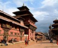
The gorge swings west this morning as we leave Dharapani and thread through a chain of Buddhist hamlets towards Bagar Chap. The route weaves between stretches of jeep track and quieter village paths, with pine stands, mani walls and plenty of stone steps to keep the legs honest. As the valley opens, Manaslu presents itself behind us, while Annapurna II flashes into view to the left. By afternoon we roll into Koto (2,600m), a friendly checkpoint village at the mouth of the Naar–Phu side valley.
Route & terrain: Dharapani → village steps and terrace paths to Bagar Chap → mixed track/foot-trail through scattered forest → gentle rise to Koto. Expect packed dirt, cobbled lanes, stone staircases and short roadside sections.
Time & effort: Typically 5–6 hours of steady walking with frequent undulations and moderate cumulative ascent. Net gain ~+740m from Dharapani to Koto. Keep a conversational pace; poles help on longer stair sections.
Mountain outlook: Clear-weather glimpses of Manaslu over your shoulder and Annapurna II across the valley. Best light often arrives late morning—keep your camera accessible.
Permits & checks (Naar–Phu): Koto hosts the entry post for the Restricted Area Permit. Keep your passport, RAP and ACAP handy for registration this afternoon or first thing tomorrow.
Trail etiquette & safety: Share narrow lanes with mules and porters—stand on the uphill side when passing. Watch footing on polished stone and dusty steps; sunglasses and a buff help in breezy sections.
Today at a glance: Trek Dharapani → Bagar Chap → Koto • 5–6 hrs • Mixed village trails & steps • Views to Manaslu & Annapurna II • Sleep 2,600m at Koto (Naar–Phu checkpoint).
This morning we formally check in at Koto and then leave the busy Annapurna Circuit, turning into the narrow, little-visited gorge of the Naar Phu Khola. The path keeps to the western (left) bank at first, weaving through quiet forest and past seasonal hamlets used by families from Naar and Phu. The contrast is immediate: fewer trekkers, steeper valley walls and a wilder feel as we follow the river upstream to a simple lodge beside the water at roughly 3,000m.
Permits & registration: Present your Restricted Area Permit (RAP), ACAP and passport at the Koto post before entering the restricted valley. Keep documents accessible for any subsequent checks.
Route & terrain: Forest paths, cliff-side traverses and occasional bridges over side streams; sections of stone steps and short, airy stretches where the gorge narrows. Expect mixed underfoot (packed earth, rock, roots) and some landslip detours after rain.
Time & effort: Typically 5–7 hours of steady walking with a gradual net ascent from 2,600m to ~3,000m. Keep a conversational pace; poles are helpful on uneven steps and riverbank sections.
Safety & comfort: The gorge can funnel wind and dust—use sunglasses and a buff. Take care on narrow ledges; give way to pack animals where used. Carry extra water and snacks today; facilities are sparse compared with the circuit trail.
Overnight stop: A new, basic lodge beside the Naar Phu Khola (twin rooms; shared facilities). Power and charging may be limited—conserve batteries. A warm sleeping bag remains recommended at this elevation.
Today at a glance: Exit the Annapurna Circuit at Koto → Enter the Naar Phu Khola gorge → Forest & riverbank trail with bridges → Overnight at gorge lodge (~3,000m) • Walk 5–7 hrs.
Today’s section feels truly remote. Beyond the junction with the Annapurna route, only restricted-permit trekkers follow the Naar Phu Khola deeper into its wild canyon. The path rises and falls repeatedly, with stretches of narrow trail cut into cliff walls above the river, interspersed with forested ribs and gravelly spurs, before the ground opens to the windswept shelf of Meta (3,560m).
Route & terrain: Gorge-side balcony paths, short stair sections, occasional stream crossings and airy traverses above the river. Underfoot: packed earth, bedrock ledges and loose gravel in places—trekking poles recommended.
Time & effort: Plan for around 5–7 hours of steady hiking with frequent undulations. Net altitude gain from ~3,000m to 3,560m; pace conservatively and snack little-and-often.
Permits & checks: Carry your RAP (Naar–Phu), ACAP and passport easily accessible; ad-hoc posts can appear at bridges or hamlet edges.
Altitude & acclimatisation: We overnight at Meta specifically to aid acclimatisation. Hydrate well, keep the afternoon easy and monitor for symptoms (headache, poor sleep, appetite loss).
Safety on narrow sections: Use the uphill side when passing others or pack animals, keep poles short on ledges, and stow loose items (wind gusts are common). A buff and sunglasses help with dust.
Optional afternoon explore: If conditions and energy allow, take a short acclimatisation walk towards the Kang Guru approach trail (turn back well before 4,000m). Keep it gentle—this is a bonus leg-stretcher, not a summit push.
Overnight: Basic lodge at Meta (twin rooms; shared facilities). Power may be intermittent; charging often pay-per-use. A warm sleeping bag remains advisable at this height.
Today at a glance: Remote gorge trekking • Balcony trails above the Naar Phu Khola • 5–7 hrs hiking • Sleep Meta (3,560m) • Optional easy acclimatisation walk PM.
A shorter, purposeful ascent to aid acclimatisation. We trace the Phu Khola on mostly level to gently rising paths towards the seasonal Khampa hamlet of Chyako. From here the trail steepens—first up to “Upper Chyako”, then on to the windswept plateau of Kyang (3,800m), known for its long mani wall and broad views high above the river.
Route & terrain: Riverside single-track to Chyako → steeper zigzags to Upper Chyako → final pull onto the Kyang shelf. Underfoot: packed earth, occasional rocky steps and short scree patches; exposure to wind on the upper plateau.
Time & effort: Allow roughly 3–4.5 hours of hiking at an easy, steady pace. Net gain ~+240m from Meta (3,560m) to Kyang (3,800m) with one sustained steeper section after Chyako.
Cultural note: Kyang is a key winter settlement for families from Phu. In autumn, you may witness transhumance—yak strings moving down from the high pastures—an evocative glimpse of Himalayan lifeways.
Altitude & care: Keep a conversational pace, hydrate well, and take short, regular rests. Watch for symptoms of AMS (headache, nausea, poor sleep) and report promptly to your guide.
Safety: Use poles on the steeper pitch above Chyako; keep to the uphill side when passing pack animals. Upper sections are exposed—secure hats/sunglasses and carry a buff for dust.
Overnight: Basic lodge in Kyang (twin rooms; shared facilities). Expect intermittent power; charging often pay-per-use. Warm sleeping bag recommended.
Today at a glance: Trek Meta → Chyako → Kyang • 3–4.5 hrs • Gentle riverside start, steeper finish • Sleep 3,800m amid wide plateau views.
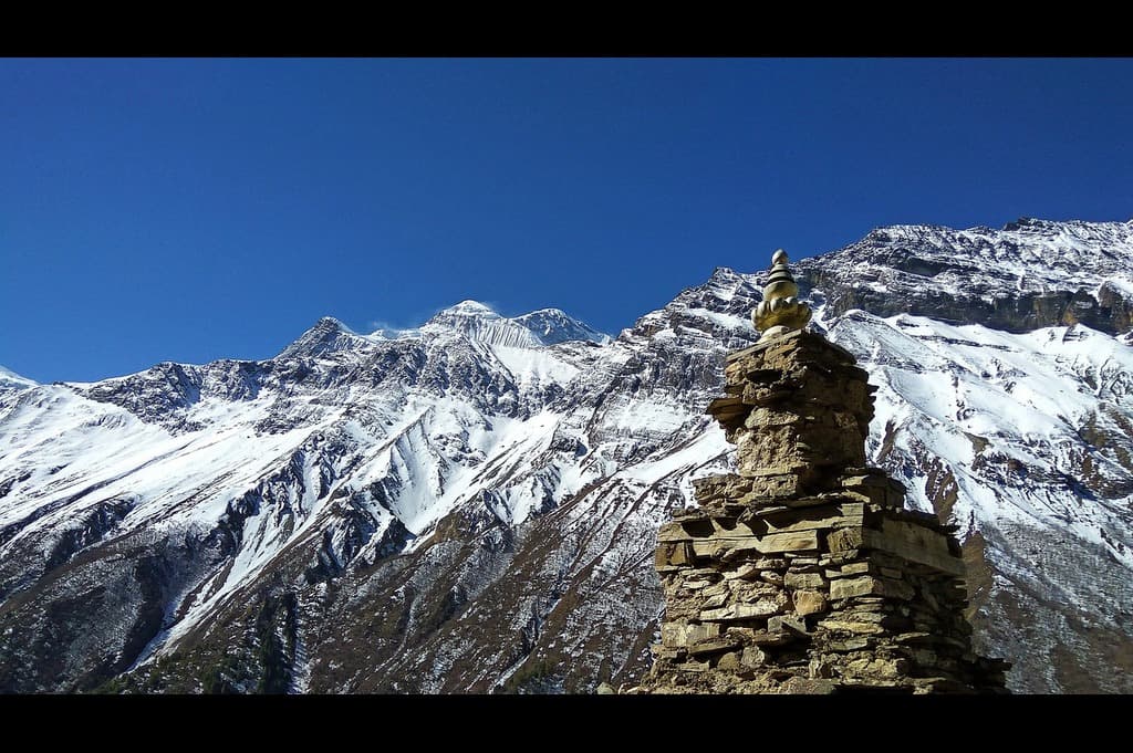
We leave Kyang on a dramatic path etched into the cliff above the Phu Khola, then drop to the riverside before a rocky headland bars the way. The route climbs out of the gorge past mani walls and chortens to the stone portal of Phuohi Yalgoe (Phu Gate). Through this gateway the valley opens and the clustered settlements of Phu appear, backed by ruined hill forts on the skyline. A final rise brings us to Phu (4,080m) by around lunchtime; the afternoon is free to wander its lanes and terraces.
Route & terrain: Cliff-side balcony trail → short descent to river flats → climb around a bluff via mani walls to Phu Gate → steady approach into the village. Underfoot: packed earth, bedrock ledges, stone steps and occasional loose gravel; some airy sections above the river.
Time & effort: Typically 4–5 hours of hiking at an even pace, with one notable climb after the bluff. Net gain from 3,800m to 4,080m; pace for altitude and take short, regular rests.
Cultural highlights: Entering Phu through its historic gate, you’ll see tiered stone houses and long mani walls beneath the remains of watch-forts. The settlement retains a strong Tibetan character—move clockwise around shrines and ask before photographing people or interiors.
Safety & etiquette: Keep to the uphill side on narrow ledges and give way to pack animals. Winds funnel through the gorge—secure hats/sunglasses; a buff helps with dust. Maintain a respectful distance around homes and prayer sites.
Village context: Phu comprises a compact cluster of stone houses in the Tibetan style and a small resident community. Expect limited services—power can be intermittent and water is precious.
Overnight: Basic lodge in Phu (twin rooms; shared facilities). Conserve batteries; charging may be pay-per-use. Keep warm layers handy—nights at 4,000m are cold.
Today at a glance: Gorge balconies → Phu Gate → arrive Phu (4,080m) by lunch • 4–5 hrs • Afternoon free to explore lanes, shrines and viewpoints.
We ease out of Phu (4,080m), pass through the stone portal of the Phu Gate and follow familiar balcony paths back into the river gorge. The trail undulates along ledges above the Phu Khola before dropping to Kyang for an unhurried lunch. In the afternoon we continue downstream to the simple lodge at Upper Chyako (3,600m), set on a shelf above the river.
Route & terrain: Cliff-side traverses from Phu → short descents to river flats → steady undulations to Kyang (lunch) → easy-angled track to Upper Chyako. Underfoot: packed dirt, bedrock benches, stone steps and occasional loose gravel.
Time & effort: Typically 4–5.5 hours net walking. Net descent ~−480m with a few short ups around bluffs. Keep a smooth, knee-friendly pace; poles help on stepped sections.
Safety notes: Stay to the uphill side on narrow ledges and give way to pack animals. Gorge winds can lift dust—carry a buff and sunglasses. Watch for loose stones on the final slopes into Upper Chyako.
Permits & courtesy: Keep your RAP and ACAP accessible for any ad-hoc checks. Move clockwise around chortens and mani walls; ask before photographing residents.
Overnight: Basic lodge at Upper Chyako (twin rooms; shared facilities). Power is intermittent and charging is often pay-per-use—conserve batteries. Nights can be cold; keep warm layers handy.
Today at a glance: Trek Phu → Kyang (lunch) → Upper Chyako • 4–5.5 hrs • Balcony paths & riverside sections • Start 4,080m → Sleep 3,600m.
A compact but varied stage. We drop out of the upper valley on zigzags to the footbridge at Naar Phedi (3,490m), where the Naar Khola cuts through a tight gorge. From the bridge, a steady climb leads away from the river, trading cliff walls for terraces and stone lanes as the path tops out at Naar (4,110m)—a striking village framed by snow-bright peaks and patchwork fields.
Route & terrain: Descend from Upper Chyako → cross the Naar Khola at Naar Phedi → sustained ascent on steps and terrace paths to Naar. Underfoot: packed dirt, stone staircases, short gravelly ribs; occasional exposure where the gorge narrows.
Time & effort: Typically 3.5–5 hours net walking. Expect a big descent to the bridge, then a long, steady climb to the village. Aim for an unhurried pace to arrive by lunchtime.
Altitude & acclimatisation: Start ~3,600m → dip to 3,490m → sleep at 4,110m. Hydrate well, snack regularly and take short breathers on steeper stair sections. Report any AMS symptoms promptly.
Naar village highlights: Stone houses in the Tibetan style, colourful gompas, long mani walls and fields of mustard and barley (in season). Local livelihoods include spinning and weaving—ask before photos; small donations help with monastery upkeep.
Afternoon options: Gentle exploration of lanes and prayer sites, or a short climb to the ridge of prayer flags above the village for broad views—keep it easy to support acclimatisation.
Safety notes: Use poles on the initial descent; keep to the uphill side when passing pack animals. Gorge winds can funnel dust—carry a buff and sunglasses.
Overnight: Basic lodge in Naar (twin rooms; shared facilities). Power intermittent; charging often pay-per-use. Nights are cold at 4,000m—warm layers and a solid sleeping bag recommended.
Today at a glance: Upper Chyako → Naar Phedi (bridge) → Naar • 3.5–5 hrs • Big descent then steady climb • Start ~3,600m → Sleep 4,110m • Afternoon to explore.
To set up a strong pass day without using high camp, we take a there-and-back acclimatisation hike from Naar (4,110m) towards the yak meadows of Kangla Phedi (≈4,530m). The route climbs gently on ancient glacial moraines, crossing sandy benches and bouldery ribs beneath the Kang La. After a short rest and photos at the meadows, we descend the same way to sleep again in Naar—classic “climb high, sleep low” strategy.
Route & terrain: Gradual ascent on moraine ridges and terrace paths; pockets of coarse gravel, flat sandy sections and occasional braided streamlets. Underfoot can be uneven—trekking poles recommended.
Time & effort: Allow roughly 4–6 hours total: 2–3 hours up towards Kangla Phedi, 1.5–2.5 hours down to Naar. Pace conservatively; snack little-and-often.
Altitude & care: High point today is around 4,530m. Hydrate well, protect from sun/wind and monitor for AMS symptoms (headache, nausea, poor sleep). If needed, turn back lower—acclimatisation is personal.
Weather & safety: Strong sun by day; sharp chill after mid-afternoon. Winds can funnel down from the pass—secure hats and sunglasses; a buff helps with dust. Keep spacing on any loose sections.
Tomorrow preview — Kang La day: Pre-dawn start from Naar to cross the Kang La (5,306m) and descend to Ngawal. Prepare 2L+ water, high-energy snacks, head torch, warm gloves/hat and windproof; microspikes may be advised in early season.
Overnight: Lodge in Naar (twin rooms; shared facilities). Repack this evening for an early departure; keep head torch and layers ready.
Today at a glance: Acclimatisation hike Naar ⇄ Kangla Phedi meadows • 4–6 hrs total • “Climb high, sleep low” • Overnight in Naar lodge.
No high camp tonight means an earlier, bigger push from Naar. We set off pre-dawn by headlamp, rising on terrace paths and moraine ribs towards the yak meadows below the pass, then continue the steady switchbacks to the crest of the Kang La (5,306m). From the top, expect a vast sweep of Annapurna II, Gangapurna, Tilicho Peak and the Great Barrier, with the valley and Humde airstrip far below. The initial descent is steep and loose (early season can hold old snow), easing onto a broad terrace where we break for a well-earned rest, before a scenic traverse leads into ridge-top Ngawal.
Route & terrain: Pre-dawn climb from Naar on terrace/moraine paths → pass the meadows below the Kang La → final zigzags to the pass → steep, loose scree (possible snow/ice) → easier terrace → long, gently undulating traverse into Ngawal. Underfoot: compact dirt, scree, occasional hard-frozen patches; poles are essential.
Time & effort: From Naar allow 10–12 hours total (includes the approach you would otherwise do from high camp). Ascent ~+1,200m to the pass; descent ~−1,640m to Ngawal. Keep an even, altitude-friendly rhythm with short, regular breathers.
Weather & safety: Wind chill is common on the crest—carry warm gloves/hat and a windproof. Microspikes may be advisable if morning snow/ice persists (guide will brief). Keep spacing on scree; use the uphill side when passing others or pack animals.
Hydration & altitude: Start with 2–3L of water and high-energy snacks. Strong sun at altitude—use sunscreen, UV400 sunglasses and a buff. Report headache, nausea or unusual fatigue early.
Ngawal arrival: Check into a comfortable lodge in this ridge village of mani walls, prayer wheels and classic Tibetan-style lanes—hot drinks, wide views and a well-earned rest to finish a landmark day.
Today at a glance: Naar → Kang La (5,306m) → Ngawal (3,660m) • 10–12 hrs • Big climb from village level, steep initial descent, panoramic traverse • Annapurna & Tilicho views throughout.
From ridge-top Ngawal (3,660m) we contour on a panoramic balcony path, looking across to the snowy ramparts of the Annapurnas, before dropping towards Pisang. Here we merge with the classic Annapurna Circuit and begin our downstream journey: a mix of cliff-side trail, river terraces and fragrant belts of pine and juniper that lead to the district hub of Chame (~2,670m).
Route & terrain: Scenic contour from Ngawal → descent to Pisang (join main circuit) → cliff-side traverse above the Marshyangdi → wooded paths and village lanes to Chame. Underfoot: compact dirt, cobbled steps, occasional loose gravel; sections of narrow bench cut into the hillside.
Time & effort: Typically 5.5–7.5 hours net walking. Net descent ~−1,000m with undulating sections. Poles help on longer stair runs; keep an even, knee-friendly pace.
Signature highlight: The sweeping rock face of Paungda Danda rears above the river like a curving stone wave—one of the circuit’s most striking natural landmarks.
Safety & etiquette: Use the uphill side when passing others or pack animals on narrow benches. Afternoon winds can funnel through the gorge—secure hats/sunglasses; a buff helps with dust.
Chame arrival: Check into a comfortable lodge in the administrative centre of the valley. Hot showers (often pay-per-use), good bakery options and phone signal make this a welcome return to creature comforts.
Today at a glance: Ngawal → Pisang → Chame • 5.5–7.5 hrs • Rejoin Annapurna Circuit • Paungda Danda viewpoint • Start 3,660m → Sleep ~2,670m.
Our final walking stage follows the Marshyangdi downstream towards Timang, not far from the junction with the Naar–Phu Khola where our side-valley adventure began days ago. Forested paths and village lanes lead us to the roadhead, where we meet our vehicles for the overland journey out of the high valleys to Besisahar.
Route & terrain (trek): Easy-angled trail from Chame through pine and juniper belts, with short stair sections and river terraces, finishing on village tracks into Timang. Underfoot: compact dirt, cobbles and occasional loose gravel.
Time & effort: Trek 2–3 hours at an easy, steady pace. After a short refresh in Timang, continue by 4WD to Besisahar (typically ~5 hours; allow longer if roadworks or weather intervene).
Road & vehicle note: The mountain road mixes tarmac with graded gravel and occasional rough patches. Seatbelts on; keep daypacks with valuables, water and a warm layer handy. Photo stops are planned where safe to pull over.
Logistics: Trek duffels travel in the support vehicle. Have permits accessible until we clear the final district post. Expect improving mobile signal as we descend; ATMs and wider services are available again in Besisahar.
Safety & etiquette: On narrow sections share the uphill side with pack animals. Dust can pick up when vehicles pass—sunglasses and a buff are useful. Hydrate well after several higher days.
Today at a glance: Trek Chame → Timang (2–3 hrs) • 4WD transfer Timang → Besisahar (~5 hrs, conditions dependent) • Rejoin lowland comforts en route to Kathmandu.
After an early breakfast we board our private vehicle for the journey back to Kathmandu. The route follows the Marshyangdi downstream to its meeting with the Trishuli, then joins the main highway for the final run into the valley. Expect changing scenery from river gorges and terraced fields to the bustling outskirts of the capital. On arrival, check in and take time to rest and freshen up.
Route & timing: Besisahar → Kathmandu by coach/minibus • typically 6–7 hours with comfort stops • target mid-afternoon hotel arrival (traffic/roadworks may affect timing).
Road & comfort: Mix of good tarmac and sections under repair. Wear seatbelts, keep a daypack with valuables/warm layer/water handy, and have motion-sickness tablets if you’re sensitive to winding roads. Planned restroom and tea breaks en route.
Arrival & downtime: Hotel check-in, hot shower, optional laundry and a short rest. This is a good window for light shopping or a gentle stroll in Thamel.
Practical notes: Keep permits and passports accessible until we’ve cleared any final checkpoints. Mobile signal improves as we near the city; ATMs and currency exchange are widely available again.
Today at a glance: Drive Besisahar → Kathmandu (6–7 hrs) • Hotel check-in & rest.
Enjoy a relaxed morning in Kathmandu before your private transfer to Tribhuvan International Airport (KTM) for your homeward flight. Take a final stroll for any last souvenirs, settle hotel incidentals and ensure trekking gear is dry and packed.
Transfer & timing: Pick-up is planned to reach the airport ~3 hours before an international departure (traffic can be busy). Keep passport, e-ticket and any frequent-flyer details handy.
Baggage & security: Place lithium batteries/power banks in carry-on. Pack trekking poles, blades and stoves in checked baggage (no gas canisters). Liquids in hand luggage must be in containers up to 100ml, in a clear bag.
Documents & money: Keep your permits until after security. Departure taxes are typically included in the ticket. Exchange or spend remaining NPR before leaving Nepal.
Souvenirs & customs: Avoid exporting antiques, sacred objects or wildlife products. Keep receipts for carpets/handicrafts. Pack fragile items well; consider checking heavier pieces.
Contingency: If your airline adjusts timings, we’ll coordinate your pick-up accordingly. Keep your phone on and monitor the airline app for gate updates.
Today at a glance: Hotel checkout → Private transfer → Arrive KTM ~3 hrs pre-flight → Depart Nepal.
| Start Date | End Date | Price | Note | AVAILABILITY | Booking |
|---|---|---|---|---|---|
| Mon, 20 Apr, 26 | Wed, 6 May, 26 | $4681 | GUARANTEED | Book Now | |
| Mon, 4 May, 26 | Wed, 20 May, 26 | $4681 | GUARANTEED | Book Now | |
| Mon, 7 Sep, 26 | Wed, 23 Sep, 26 | $4681 | GUARANTEED | Book Now | |
| Mon, 5 Oct, 26 | Wed, 21 Oct, 26 | $4681 | GUARANTEED | Book Now | |
| Mon, 2 Nov, 26 | Wed, 18 Nov, 26 | $4681 | GUARANTEED | Book Now | |
| Mon, 1 Mar, 27 | Wed, 17 Mar, 27 | $5886 | GUARANTEED | Book Now | |
| Mon, 26 Apr, 27 | Wed, 12 May, 27 | $5886 | GUARANTEED | Book Now | |
| Mon, 3 May, 27 | Wed, 19 May, 27 | $5886 | GUARANTEED | Book Now | |
| Mon, 6 Sep, 27 | Wed, 22 Sep, 27 | $5886 | GUARANTEED | Book Now | |
| Mon, 4 Oct, 27 | Wed, 20 Oct, 27 | $5886 | GUARANTEED | Book Now | |
| Mon, 1 Nov, 27 | Wed, 17 Nov, 27 | $5886 | GUARANTEED | Book Now |
| Place | Accommodation | Description |
|---|---|---|
| Kathmandu | City hotel | Twin/double share with breakfast; central location; en-suite where available; reliable hot water & Wi-Fi. Single supplement on request. |
| Jagat / Dharapani / Koto | Teahouses / lodges | Simple twin rooms; shared bathrooms common; dining room heating; pay-per-use hot showers & device charging; Wi-Fi variable. |
| Meta | Teahouse / lodge | Basic twin rooms; mostly shared facilities; intermittent power; bring a warm sleeping bag (comfort −5 °C to −10 °C). |
| Kyang / Phu | Basic lodges | Very simple rooms; thin walls; limited hot water; charging often pay-per-use; unforgettable cliff-side setting and strong cultural feel. |
| Upper Chyako | Basic lodge (where available) | Seasonally open; simple twin rooms; shared facilities; services limited. Your guide will confirm availability in season. |
| Naar | Lodge / teahouse | Twin rooms; shared bathrooms typical; intermittent power; superb village ambience and gompas nearby. |
| Ngawal | Newer lodge (ridge-top) | Comfortable rooms by circuit standards; hot showers (often pay-per-use); broad Annapurna views; phone signal usually better. |
| Chame / Timang | Teahouses / lodges | Good rest-stop standards; bakeries and shops nearby; charging/Wi-Fi more reliable than higher up. |
| Notes | Bedding & luggage | Porter-carried duffel up to ~15 kg per trekker; you carry a 20–30 L daypack. Lodges provide blankets, but a warm sleeping bag + liner is recommended. |
Important Information (read before you book)
Altitude & health: Highest point Kang La 5,306 m; highest sleep ~4,110 m (Naar). Risk of AMS exists—ascend gradually, hydrate, protect from sun/wind, and report symptoms (headache, nausea, poor sleep) promptly.
Terrain & fitness: 4–7 hrs walking most days; cliff-cut balconies, stone steps, occasional scree. One very big pass day from Naar → Kang La → Ngawal. Trekking poles highly recommended.
Road & delays: Approach and exit are overland (4WD/coach). Landslides, roadworks or weather can cause delays—flexibility and a buffer day help.
EU/UK flight safety: International flights are arranged with reputable carriers that meet EU/UK safety standards (we monitor official guidance). No domestic flights on this itinerary.
Insurance (mandatory): Comprehensive policy covering trekking to ~5,300 m, helicopter evacuation, medical costs and trip disruption. Carry your policy and 24/7 emergency numbers.
Permits & compliance: Naar–Phu RAP and ACAP required; show originals at Koto and village posts. Drone/monastery photography may be restricted—seek permission and respect local customs.
Risk acknowledgement: Mountain travel involves inherent risks (altitude illness, slips/falls, rockfall, dust/wind exposure, road disruption). You agree to follow your guide’s safety instructions at all times.
Hygiene & water: Use boiled/treated water; carry bottles/bladder; wash/sanitise hands regularly. Advise dietary needs early; stick to hot, freshly cooked meals at altitude.
Money & connectivity: Currency NPR; ATMs limited beyond Dharapani—carry small bills. Local SIMs available in cities (passport required). Power/charging often pay-per-use; Wi-Fi patchy above Koto.
Kit highlights: Broken-in boots; warm layers + windproof; hat/buff & UV400 sunglasses; head torch; sleeping bag (comfort −5 °C to −10 °C); 2–3 L water capacity; personal meds & blister care; sunscreen & lip balm.
Responsible travel & porter welfare: Ethical loads (~15 kg per client duffel), fair pay and proper kit for porters. Follow leave-no-trace principles; refill bottles; minimise single-use plastics.
24/7 support: In-country operations team and duty manager available round-the-clock during your trip.


Embark on an Unforgettable Journey Across Nepal and India – The…
Embark on an unforgettable 12-day round-trip through central Nepal, where…

You will explore Nepalese culture, heritage, wildlife, adventure with…


Our team is at your service to help you with your booking issues or answer any related questions
1-888-214-4856
Start planning your tailor-made holiday by contacting one of our specialists of Nepal
call our specialists on
1-888-214-4856
Written by our travel specialists, our brochures highlight the incredible places you can explore and help simplify the choices when planning your trip. Whether you’re ready to enquire or just gathering ideas, we’re here to support you.
Our customers praise our staff’s professionalism and the world-class service we consistently provide.
ATOL and ABOT protected company. Plus, a refund within 14 days if your holiday is cancelled.
Our specialists have in-depth knowledge from extensive travel or living in the regions they manage.
Our prices are unmatched. Find a better deal, and we’ll refund the difference within 24 hours.
 Nepal
Nepal Singapore
 Taiwan
 India
India Bhutan
 Tibet
Tibet China
China Sri Lanka
 Thailand
 Cambodia
 Vietnam
 Laos
Laos Japan
Japan South Korea
 Maldives
 Malaysia
 Indonesia
 Philippines
 Mongolia
 Uzbekistan
 Ethiopia
 Kenya
Kenya Madagascar
 Mauritius
 Morocco
 Namibia
 Rwanda
 South Africa
 Tanzania
 Tunisia
 Uganda
 Zimbabwe
 Egypt
Egypt Jordan
 Oman
Oman Saudi Arabia
 United Arab Emirates
 Armenia
 Bulgaria
 Croatia
 Cyprus
 Czech Republic
 France
 Greece
 Iceland
 Ireland
 Italy
Italy Malta
Malta Portugal
 Romania
 Slovenia
 Spain
Spain Turkey
 America
 Belize
 Canada
 Costa Rica
 Guatemala
 Mexico
 Panama
 Argentina
 Brazil
 Chile
Chile Colombia
 Ecuador
 Peru
Peru Australia
 French Polynesia
 New Zealand