-

- Home
- Company
- Destinations
- Activities
- Essential Info
- News
- Contact


22 days from $6888 pp with roundtrip flights
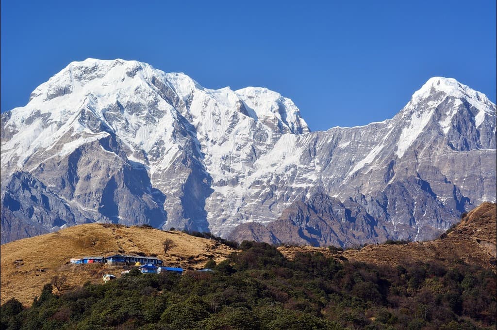
Your journey opens with a pre-dawn transfer to Manthali (Ramechhap) and a dramatic hop into Lukla, then quickly trades the busy Everest highway for quieter ridges and farm hamlets. Crossing Pangkongma La, you enter the wild Hinku Valley: bamboo and rhododendron forests give way to yak pasture and glacial benches as you descend to Kote and follow the river toward Tangnag (Thangnak). Two nights here build altitude resilience (acclimatisation) with a ridge hike to ~5,000 m and sweeping views of Kyashar and Kusum Kanguru—a superb warm-up for the Mera Peak trek.
A short, steady push leads to Khare (~5,000 m), your base for glacier skills, rope practice, and final gear checks. From here you step onto the ice, cross the windy Mera La, and rise to the tight, exposed High Camp (~5,800 m). Summit morning begins around 02:00: roped teams move in crampons over broad, moderate slopes before a steeper final ~50 m on a fixed line to reach Mera Peak (Central). Sunrise paints a horizon from Kangchenjunga through Makalu, Lhotse and Everest to Cho Oyu—an unforgettable reward. You abseil the headwall, regroup at High Camp for hot drinks, and descend all the way to Khare. A built-in contingency day maximises safe summit chances if weather or conditions shift.
The return traces the Hinku Valley back to Kote, then climbs toward the twin cols of Zatrwa La for a dramatic re-entry to the Lukla side—steep steps that can be icy, with vast look-backs across much of your route. One last mountain morning carries you down to Lukla, followed by a flight to Manthali (Ramechhap) and a road transfer to Kathmandu. A final free day lets you wander Boudhanath, Swayambhunath, and the old bazaars before departure—legs pleasantly heavy, camera full, and the high white arc of the Himalaya fixed in memory. This concise overview is ideal for travellers searching for a guided Mera Peak expedition or a detailed Mera Peak trekking itinerary in Nepal.
Day 1 : DEPART NEW YORK → KATHMANDU
Day 2 : ARRIVE KATHMANDU — TRANSFER & AT-LEISURE
Day 3 : PRE-DAWN DRIVE TO MANTHALI → SCENIC HOP TO LUKLA; DESCEND VIA SURKE AND CLIMB CHUTOK LA TO PIUYAN
Day 4 : LEAVE THE MAIN TRAIL — CLIMB VIA KHARI LA TO PANGKONGMA
Day 5 : OVER PANGKONGMA LA → DESCEND TO THE HINKU KHOLA → CLIMB TO NASHING DINGMA
Day 6 : STEEP PULL TO SURKYE LA (SURKE LA) → SUMMER PASTURES OF CHHOLEM KHARKA
Day 7 : HIGH COLS TO KHOLA KHARKA — OVER PANGKONGMA LA & SURKE LA TO THE PANCH POKHARI LAKES
Day 8 : KHOLA KHARKA RIDGE & VIEWPOINTS → STEEP DESCENTS TO THE HINKU VALLEY → KOTE
Day 9 : UP THE HINKU VALLEY — KOTE → SAURE → TANGNAG (TAGNAG)
Day 10 : ACCLIMATISATION DAY — RIDGE HIKE ABOVE TANGNAG (~5,000 M)
Day 11 : TANGNAG → DIG KHARKA BENCHES → KHARE (MERA BC) — SHORT ASCENT, BIG VIEWS
Day 12 : ACCLIMATISATION AT KHARE — GLACIER APPROACH & SKILLS CLINIC (ICE AXE, CRAMPONS, ROPE)
Day 13 : KHARE → “CRAMPON POINT” & MERA LA ACCLIMATISATION — RETURN TO KHARE
Day 14 : KHARE → MERA LA → HIGH CAMP — INTO THIN AIR AND BIG HORIZONS
Day 15 : SUMMIT PUSH — MERA PEAK (CENTRAL)→ DESCEND TO KHARE
Day 16 : CONTINGENCY DAY — WEATHER/HEALTH BUFFER FOR THE MERA SUMMIT (OR DESCENT TO KOTE IF ALREADY TOPPED OUT)
Day 17 : RETRACE THE HINKU VALLEY — VIA TANGNAG TO KOTE
Day 18 : STEEP CLIMB TOWARD ZATRWA LA — KOTE → TOKTAR → CHETRABU
Day 19 : CROSS ZATRWA LA (TWO COLS) → LONG DESCENT TO LUKLA
Day 20 : FLY LUKLA → MANTHALI (RAMECHHAP) & ROAD TRANSFER TO KATHMANDU
Day 21 : KATHMANDU AT LEISURE — TEMPLES, STUPAS & OLD-CITY LANES
Day 22 : DEPART KATHMANDU — ONWARD JOURNEY
Your journey to Kathmandu begins at NEW YORK. Arrive with plenty of time, glide through check-in, and clear security unrushed. In the departure hall, boards glow with far-flung cities, the scent of coffee drifts across the concourse, and that pre-adventure buzz kicks in—this is the first step toward the high trails of the Himalaya.
With boarding passes in hand, keep essentials close—passport, meds, chargers, a warm layer, and headphones. If you have lounge access, settle into a calm pre-flight ritual: a light meal, a hot shower, and one last message to loved ones. Most routings are one-stop via Doha, Istanbul, Dubai or Abu Dhabi; confirm your gate early and allow time to stretch before boarding.
Once airborne, the cabin dims and the long-haul rhythm begins. Hydrate, take gentle aisle walks, and cue a film or audiobook. Reset your watch to Nepal Time (UTC+5:45) to help your body clock. As you cross the night sky, picture tomorrow’s first sight of terraced hillsides and temple spires—Kathmandu will be waiting when the wheels touch down.
Travel notes:
Touch down at Tribhuvan International Airport (KTM), clear immigration (visa on arrival available for most nationalities), and collect your bags. Your representative will meet you just outside the arrivals hall for the private transfer into the Kathmandu Valley—a short drive, traffic permitting, past roadside shrines, coffee stalls, and hand-painted trucks.
Check in at Hotel Norbulinka (or similar). Freshen up, hydrate, and take things gently after the overnight flight. When ready, step out for a light orientation in Thamel: browse prayer flags and trekking stores, try steamed momo dumplings or a cup of masala tea, or unwind in the leafy Garden of Dreams. If time/energy allow, a taxi to dusk kora at the Boudhanath Stupa is a serene first taste of the city.
Evening is at leisure. Choose a rooftop spot for a simple Nepali dinner (think dal bhat, veg curries, warm breads) and an early night to sync with local time. Keep tomorrow easy—your body will thank you at altitude later in the trek.
Practical notes:
Alarms ring before sunrise for a ~3:00 a.m. departure. With a packed breakfast and daypacks handy, we drive ~4 hours to Manthali (Ramechhap) Airport, then board the short, spectacular mountain flight to Lukla—gateway to the Khumbu and jumping-off point for the Mera Peak approach. On arrival, the air is crisp, prayer flags snap, and the village hums with outfitters and mule trains.
Trekking begins south out of Lukla with a steep descent on stone steps to the quiet hamlet of Surke, tucked beside the river. From here the character changes: a sustained climb to Chutok La (also known locally as the Paiya ridge) winds through mixed forest and terraced hillsides, with glimpses across side valleys and farms. Cresting the pass, we contour into a side valley and make a gentle descent to Piuyan (Paiya), our first overnight on the trail.
Check into a simple teahouse, swap boots for sandals, and enjoy a hot drink while clouds drift over the ridge. If legs feel good, a short stroll beyond the village offers broad views back towards Lukla’s terrace and tomorrow’s undulating path ahead.
Day facts
Practical notes: Mountain flights are weather-dependent—be ready for early check-in and flexible timings. The descent to Surke can be slick in the wet; trekking poles help. Keep to the uphill side when mule/yak trains pass, and carry a warm layer for the breezy Chutok La crest.
We turn our backs on the busy Khumbu highway and strike east, the path lifting steeply from the valley through terraced farmland and stone-walled fields. Morning air is cool and clean; water mills chatter, and the trail zigzags between stands of rhododendron and farm hamlets scented with wood smoke.
The gradient eases as we gain the shoulder of Khari La (≈3,050 m / 10,000 ft). From this broad saddle, look back for fine views to Numbur and Karyolung, their glaciated walls rising blue and hard above layered ridges. We contour onward across field edges and pockets of forest, then descend gently into a side valley before a final lift to the small trading village of Pangkongma—gateway to quieter trails bound for Mera Peak.
Arrive mid-afternoon and settle into a simple teahouse. With time in hand, wander the lanes lined with mani walls, or sit with tea and watch porters and mule trains thread the ridge at golden hour.
Day facts
Practical notes: The initial climb is sustained—small steps, steady pace, and frequent water sips help. Terraced paths can be slick after rain; trekking poles and grippy soles are useful. Keep a warm layer for the breezy Khari La saddle and small NPR notes for tea/fruit along the way.
We climb straight into cool shade, the path threading bamboo and rhododendron as it rises toward the airy notch of Pangkongma La (≈3,170 m / 10,400 ft). Look back for clean morning views of Numbur and Kongde; ahead, the shoulder of Naulekh shows and, just below the pass, a thrilling first glimpse of the south face of Mera.
From the crest the trail tips steeply down on stone steps and earthy switchbacks, dropping through mixed forest and pockets of terraced fields with wide views rolling away to the lower Himalaya. Near the valley floor we pause at a tiny lodge above the water for a simple lunch, then cross the Hinku Khola on a suspension bridge strung with prayer flags.
The afternoon brings a steady, two-hour climb on the east side of the valley, weaving between mossy boulders and farm plots to reach the peaceful perch of Nashing Dingma, where we settle into a teahouse and watch dusk settle on the forested ridges.
Day facts
Trail tips: The descent off Pangkongma La can be slick—poles help, especially if damp. Keep to the uphill side when pack animals pass. In warmer months, leech socks are useful near the river. Refill bottles at lunch (treat water) before the afternoon climb.
The morning sets the tone with rolling ups and downs before the trail bites in for a steeper climb to the airy notch of Surkye La (also written Surke La). Pines thin, rhododendron reappears, and the breeze carries cool hints of the higher country ahead. Cresting the pass, we drop packs for a tea stop at the simple teahouses just beyond—an easy place to catch breath and watch prayer flags snap in the wind.
From here, the path continues upwards on gentler gradients, weaving over yak tracks and grassy shelves to the wide, open grazing grounds of Chholem Kharka. Expect to arrive around late lunch time. With energy left, an optional ridge stroll in the afternoon offers big horizons and helps with acclimatisation before we settle into the teahouse for a quiet high-country evening.
Day facts
Practical notes: Short day but steep sections—pace steadily and sip often. The pass can be windy: carry a warm layer, hat and gloves. Trails can be slick after rain; poles help on the descents. Afternoon ridge walks are optional—turn back if clouds build or if you feel any altitude symptoms.
We leave the last trees behind and step into summer-grazing country, where stone huts dot open hillsides and yak paths criss-cross the turf. The trail wastes no time—steep stone steps lead to a first high saddle at roughly 4,300 m / 14,100 ft, a fine balcony over blue ridges and distant river clefts.
From the col the path trends upward again, tugging across a rib of hillside to a second crest near 4,470 m / 14,665 ft. On a clear day the far eastern skyline sharpens and you can pick out Kangchenjunga and its striking neighbour Jannu, tiny yet unmistakable beyond a sea of lower summits. Prayer flags flick, the air is thin and clean—pace stays slow and steady.
A stony traverse eases down to the Panch Pokhari—a string of small, sacred lakes where wind ripples the surface and cairns mark the way. From here it’s a short continuation around the basin to Khola Kharka, a cluster of seasonal lodges where we check in, warm up over tea and watch evening light settle on the high pastures.
Day facts
Practical notes: This is a short but high day—move at conversational pace, layer for wind on the crests, and protect against strong sun. Trails are rocky in places; poles help on the short descents toward the lakes. If clouds build or you feel altitude symptoms, keep breaks frequent and communicate with your leader.
With no lodges between stops today, we set out early from Khola Kharka carrying extra water and trail snacks. A brisk 30-minute stone-step climb leads to fluttering prayer flags and a shoulder with big viewpoints across to Numbur, Pikey Peak and the Lamjura Pass. From this corner, the path contours airy hillsides before dropping very steeply to the Mojang Khola.
We cross the stream and continue down to meet the larger Hinku Khola, the river loud in its boulder bed. A rolling riverside trail then trends upstream to a bridge and the hamlet of Kote (≈3,600 m / 11,810 ft). Expect a late lunch at the lodge; with time in hand, wander the cluster of houses, watch mule trains arrive, or sit by the river as cloud drifts along the valley walls.
Day facts
Practical notes: There are no food stops en route—carry 2–3 L water and high-energy snacks. Steep descents can be slick; trekking poles save knees. In warmer/wet months, consider leech socks near the lower streams. Refill in Kote (treat or boil).
We leave Kote on a rocky riverside path, following the Hinku Khola upstream through birch and juniper. Within minutes the skyline sharpens and the three summits of Mera lift ahead—an inspiring compass for the day. The trail rolls over boulder fans and landslide crossings (short, cautious steps), then slips back onto level benches where the river braids and glints below.
As the valley narrows, the walls steepen and new giants appear: needle-backed Kyashar straight ahead, with Kusum Kanguru and East Peak edging into view. We pause for tea at Saure, then continue the steady ascent into a classic U-shaped glacial trough—wind-polished slabs, yak pasture, and the sound of meltwater under stone.
We reach Tangnag (≈4,350 m / 14,272 ft) for a late lunch and settle in for a two-night stay. The village sits ringed by dark cliffs and snow ribs—a dramatic, sheltered base for acclimatisation. Spend the afternoon with a gentle stretch above the lodges or simply rest, hydrate, and watch cloud bands drift across Kyashar’s face.
Day facts
Practical notes: Carry extra water and snacks—services between Kote and Tangnag are sparse. Move one at a time across landslide sections and follow guide spacing. Today’s altitude gain is significant: keep a conversational pace, protect from sun/wind, and continue hydrating on arrival. You’ll spend two nights here to acclimatise.
A slower start to help your body adjust. After breakfast we pack light daypacks (water, snacks, shell, warm layers) and head up a steady trail to a south-facing ridge above Tangnag. The path climbs gradually over yak pasture and moraine slabs toward a broad high point around ~5,000 m / 16,400 ft.
From the crest the amphitheatre opens wide: serrated Kusum Kanguru, elegant Kyashar, East Peak and the notch of the Mera La line the skyline. Look back for a superb bird’s-eye view of Tangnag tucked deep in its U-shaped valley. We take unhurried breaks—photographs, hot tea from a flask—then descend the same way to arrive in time for lunch.
The afternoon is for rest and hydration. Stretch, sort kit for the days ahead, or take a gentle leg-loosener around the meadows. Keep effort easy today—acclimatisation is the goal.
Day facts
Acclimatisation tips: “Climb high, sleep low” is the plan—keep a conversational pace, sip water regularly, protect from strong sun/wind, and descend if you feel persistent headache, nausea or dizziness. Poles help on the rocky descent; carry a warm hat and gloves for the breezy ridge.
Today is intentionally short and steady. We climb straight out of Tangnag, passing prayer flags with a balcony view of the glacier streaming off Kyashar. The gradient soon eases as the trail threads the upper valley, skirting the meadows of Dig Kharka and slabs polished by old ice.
A final, slightly steeper pull leads to the cluster of lodges at Khare (≈5,000 m / 16,404 ft)—our trekking base for Mera Peak. We arrive for lunch and keep the afternoon free for rest, kit checks and soaking up the skyline. From here the panorama is superb: the three summits of Mera front and centre, with Charpati Himal, Kyashar and other Khumbu giants hemming the horizon.
Use the downtime to organise layers, test head torches and water systems, and take a gentle leg-loosener above the lodges if you feel good. Hydration and an early night set you up well for the altitude ahead.
Day facts
Practical notes: Keep a conversational pace—today’s gains are about acclimatisation, not speed. Afternoon weather can turn breezy/cool; have a warm layer handy. If offered, attend a pre-climb briefing or informal gear check with your guide. Continue the “drink little, drink often” routine.
Today is dedicated to altitude adaptation and skills practice. After breakfast we kit up with helmets, harnesses, crampons and ice axes and hike from Khare (≈5,000 m) toward the lower edge of the glacier on the line of the Mera La. On firm snow we run through movement patterns and rope routines at an unhurried pace, focusing on efficiency and safety for the high days ahead.
Your guide covers flat-footing and front-pointing, self-arrest with the ice axe, clipping and jumar technique on fixed lines, and simple rope travel. Expect generous breaks to manage breathing and to keep the emphasis on learning rather than mileage. We return to Khare around midday for a full equipment check, then rest and hydrate through the afternoon.
Mandatory: The equipment check and practice session are compulsory before the climb.
Day facts
Practical notes: Bring warm layers, shell, liner gloves plus insulated gloves, sunglasses/goggles, sunscreen and 1–2 L of water. Keep movements deliberate; if you feel persistent headache, nausea or dizziness, inform your guide and descend. After lunch, pack and label summit gear for an early start tomorrow.
A short but punchy acclimatisation day. We leave Khare on a steep, rocky trail with widening views to the Mera peaks and the cirque above camp. The path steepens toward a narrow gully—our typical “crampon point”—where we don helmets and crampons for secure footing on mixed rock/firm snow.
Topping the gully, we step onto the lower glacier where the angle eases. Roped as conditions require, we make a measured ascent toward the Mera La, practicing steady pacing and pressure breathing. After a short rest and photos at the day’s high point, we retrace our steps—carefully down the gully—back to the lodges at Khare for a relaxed afternoon and gear sort.
Day facts
Practical notes: Wear helmet and crampons as directed; gully can be icy. Keep 3-point contact on rock, and maintain rope spacing on the glacier. Use a turn-around time if weather shifts. Hydrate steadily; protect from strong sun/wind at altitude. Afternoon is for rest, packing, and final gear checks.
We shoulder packs at first light and rejoin yesterday’s line toward the glacier, stepping carefully up the familiar rocks to reach the windy notch of the Mera La. This col can be a fridge—expect spindrift, a biting breeze and spectacular views. Beyond, the angle eases and we settle into a steady, economical rhythm across the broad back of the glacier, moving roped as conditions require. Crevasse patterns shift season to season; the track weaves between snow bridges and wind-scoured ribs as the world drops away on either side.
By late day we crest the platform of High Camp (≈5,800 m / 19,030 ft), a compact eyrie chopped into the ice with room for a handful of tents and a view that beggars belief. On clear afternoons you can trace five 8,000ers from east to west—Kangchenjunga, Makalu, Lhotse, Everest and Cho Oyu—with a sweep of lesser giants in between. We run a final gear check, prep clothing in summit order, and sip hot drinks while daylight thins. When the last ember-orange slides off Makalu, we slip into sleeping bags to bank rest for the summit push.
Heads-up: High Camp is very cold and minimalist; tent space is tight. For safety and warmth, meals and briefings are delivered tent-to-tent.
Day facts
Practical notes: Pack big warmth (down parka, insulated mitts, buff/balaclava). Keep batteries and water inside your layers to prevent freezing; consider a hot-water bottle for the bag. Sunglasses/goggles and high-SPF are essential on the glacier. Maintain rope spacing and a deliberate pace—today is about efficiency and oxygen management. Set alarms, pre-rig crampons/harness, and stage summit layers for a quick pre-dawn start.
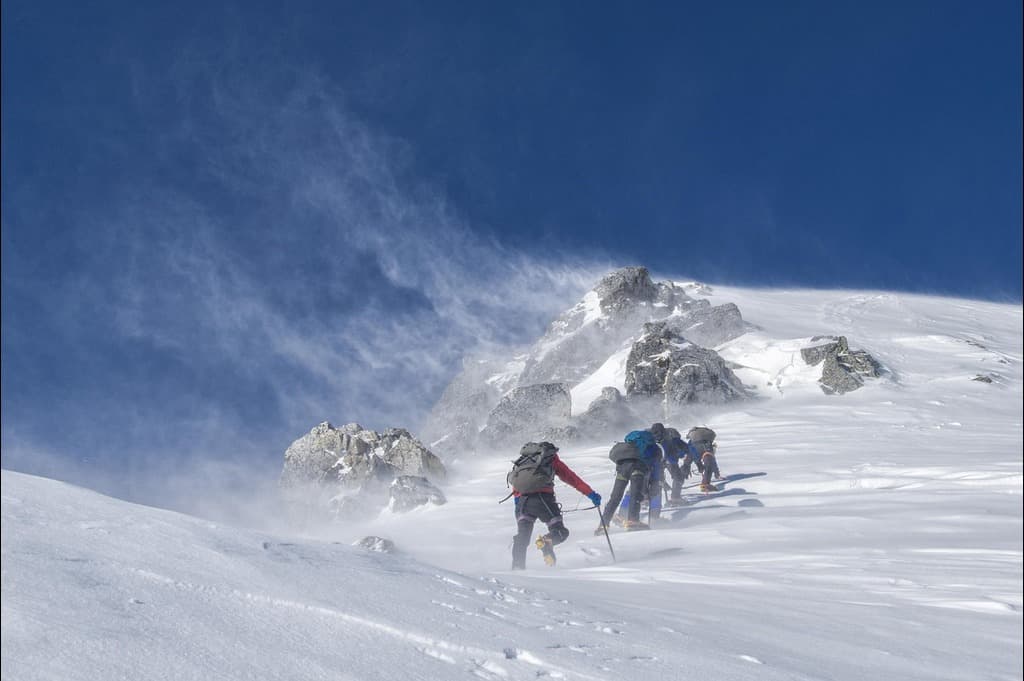
Alarms sound in the deep night for a ~02:00 departure. We gear up fast in the cold, clip into rope teams, shoulder ice axes and step onto the wide, moonlit glacier in crampons. The slope is mostly moderate but the altitude slows everything, and katabatic winds can bite; we move steadily, skirting open crevasse zones as led by the guide.
As a steel-blue dawn leaks over the Himalaya, the track steepens to the left-hand ridge before easing as it swings right toward the final pyramid. Below the summit we pause at a small col while the Sherpa team fixes a safety line for the last section. The concluding ~50 m/165 ft pitch is the day’s steepest; we ascend one-by-one using jumars on the fixed rope.
The summit panorama is outrageous at sunrise—Kangchenjunga glowing in the east, Makalu, Lhotse and Everest front and centre, and Cho Oyu holding the western skyline. Breathe, take a careful team photo, then begin the descent: a controlled abseil back to the col, regroup, and continue roped down-glacier to High Camp for hot soup. From there, we keep descending all the way to Khare, usually arriving late afternoon—tired, happy, and back in thicker air.
Safety & pacing: Summit morning is extremely cold and often windy—dress in layers, keep moving, minimize stops. If the guide deems any member of a rope team unfit to continue, the entire rope must descend together for safety. Crevasse patterns change each season; follow guide spacing and instructions at all times.
Day facts
Practical notes: Pre-stage layers, snacks and water the night before. Keep water inside your jacket to prevent freezing; consider insulated bottles. Goggles/sunglasses and high-SPF are essential. Use pressure breathing on the climb, and keep hands/feet warm with liner + insulated gloves and quality socks.
This day is deliberately kept flexible. Mountain weather, team health, and glacier conditions can shift quickly, so we hold this buffer to give the group the best, safest chance of a Mera summit. If high winds, cold fronts, or visibility forced a turn-around or postponement, we can re-attempt today (guide discretion).
If we summited yesterday and conditions are settled, we use the buffer to descend and start our journey out—typically dropping from Khare back through Tangnag and on to Kote (time permitting), enjoying thicker air, hot drinks, and a gentler pace before the return toward Lukla.
Guide’s call: Use of this day—whether for a summit re-attempt, active rest, or descent—is at your leader’s discretion for safety and best outcomes.
Day facts
Practical notes: Keep summit kit packed and ready at breakfast in case we move early. If descending, protect knees with poles and keep a steady sip rate—altitude gains/losses still affect energy. Any itinerary adjustments today help safeguard overall safety and comfort for the journey out.
We turn down-valley this morning, easing off the altitude and letting the rhythm of the Hinku Khola guide our steps. The path undulates gently across yak pasture and glacial benches, stone walls giving way to open meadows and wide views back toward the cirque above Tangnag. We pause in Tangnag for an early lunch and hot drinks, swapping summit stories while clouds slide along Kyashar’s dark walls.
Beyond the village the valley broadens and the air softens. The trail threads boulder fans and polished slabs before slipping into denser forest: rhododendron, oak, pine and birch. Birdsong replaces wind on ice; the river grows louder. Short rises and descents keep legs honest, but the general trend is mercifully downward toward the warmth of Kote.
By late afternoon we step onto the bridge and into Kote (≈3,600 m / 11,810 ft), where a teahouse welcome awaits. Rest feet, rehydrate, and enjoy an unhurried evening—this is a good place to relive the last few high days in the comfort of thicker air.
Day facts
Practical notes: Poles help on the rolling descents. Treat or boil river/refill water en route. Forest sections can be slick after rain; keep spacing on the steeper pitches. Enjoy the altitude drop—eat well and stretch to speed recovery for the final days out to Lukla.
A tougher, high-effort day as we begin the long ascent toward the Zatrwa La, the pass that leads back to Lukla. From Kote the rocky trail follows the Hinku Valley for a couple of hours, with very steep stone steps both up and down. We finally leave the river behind and hit a sustained forest climb, switchbacking beneath rhododendron and pine.
We pause for an early lunch at Toktar, a tiny cluster of teahouses tucked in the trees. Through gaps in the canopy the summit of Mera peeks back from afar—a fine marker of how far we’ve come. After lunch, the gradient persists as the forest thins to scrub; the views open across the valley and, on clear days, all three Mera summits line up with Peak 41 and Naulekh. It’s a rewarding section where you can trace much of the route walked over the past couple of weeks.
A string of prayer flags marks the point where the trail eases. From here it’s a gentler traverse to the lodge at Chetrabu (≈4,225 m / 13,860 ft), an airy perch with a striking look at Mera’s vertical west face. Hot drinks, warm layers, and an early night set us up for tomorrow’s crossing.
Day facts
Practical notes: Expect long, steep steps—trekking poles and steady pacing help. Carry 2–3 L of water and top up at Toktar (treat/boil). Weather can switch quickly near tree line; keep a warm layer and shell accessible. Tonight is high—hydrate, stretch, and rest well ahead of the pass.
A technical mountain day with big elevation loss. We leave Chetrabu and climb steeply on a stony path toward the first—and higher—shoulder of the Zatrwa La at about 4,640 m / 15,525 ft. A tiny tea shop often operates near the crest; from here the panorama opens across a field of Khumbu peaks.
The initial descent is short but steep and can be icy; we fit crampons or microspikes as needed. The track then contours an exposed hillside—careful footwork and spacing—before rising gently to the second Zatrwa La at roughly 4,540 m / 14,895 ft. Beyond this col a very steep descent drops to Kharka Tseng; in snow/ice our team may employ crampons, ice axe and rope for security.
After a snack lunch we continue down a rocky trail to Chutenga, then wind through pastures and scattered pines for the last couple of hours to Lukla (≈2,800 m / 9,185 ft). Expect a late-afternoon arrival and a well-earned hot drink—civilisation feels close again.
Day facts
Practical notes: Carry crampons or microspikes and fit them early if surfaces glaze. Keep poles ready for long, knee-testing descents. The contour between passes is exposed—maintain spacing and follow guide instructions. Pack warm layers and wind protection for the cols; water and snacks for a full mountain day.
We rise early for the short mountain hop from Lukla to Manthali (Ramechhap). On clear mornings the views spill away in layers of ridges and snow peaks—have a camera handy. After landing, we rendezvous with our vehicle and begin the 4–5 hour drive back to Kathmandu, rolling past river canyons, terraced fields and roadside tea stalls.
Back in the city, check in at Hotel Norbulinka (or similar), where hot showers and creature comforts await. The rest of the day is at leisure: decompress with a massage, sort laundry, or take an easy stroll for coffee and souvenirs in Thamel. This evening, you might toast the trek with a cool beer or a warm dal bhat—your call.
Day facts
Practical notes: Mountain flights can be delayed by weather—keep essentials in your daypack and snacks/water for the road. Baggage allowances on the Lukla sector follow your ticketed carrier’s rules; keep valuables/fragile items in carry-on. The Manthali road is winding—motion-sickness tablets help if you’re prone.
A well-earned free day in Kathmandu. Sleep in, enjoy breakfast at the hotel, then choose your own pace: wander craft-lined alleys in Thamel, trace royal courtyards at Durbar Square, or head for the city’s spiritual landmarks. At Swayambhunath (the “monkey temple”), prayer wheels spin and views sweep across the valley; at vast Boudhanath Stupa, join the gentle clockwise kora with butter-lamp glow and rooftop tea houses. Down by the Pashupatinath temple complex, observe respectfully from signed areas as ceremonies unfold along the Bagmati River.
Prefer a quieter interlude? Tuck into a book at the leafy Garden of Dreams, browse fair-trade boutiques, or try a Nepali coffee roastery. For food lovers, momos and thukpa are easy wins; spice-curious travellers can seek out a Newari lunch in Patan’s brick plazas (easy taxi ride).
Optional excursions (book/pay locally, subject to availability)
Ask at reception or your tour leader for timings and prices.
Practical notes
At the appointed time, meet your driver for the transfer to Tribhuvan International Airport (KTM). Take a last look at the prayer flags and terraced hillsides—memories of glaciers, high passes and valley villages will travel with you.
At the airport, allow ample time for check-in and exit formalities (international flights generally recommend arriving 3 hours before departure). Keep passports, e-tickets and valuables handy in your carry-on. If you have an early departure, the hotel can arrange a packed breakfast on request.
Practical notes
Accommodation: — | Meals included: Breakfast (time permitting)
Notes: Personal climbing gear (boots, crampons, harness, ice axe, etc.) is usually not included—hire can be arranged on request. Exact inclusions may vary slightly by departure; your final invoice/itinerary is the binding reference.
Notes: If you plan to hire gear locally, allow time for fittings in Kathmandu/Khare and budget a refundable deposit. For safety, insurance must explicitly cover helicopter evacuation at altitude.
| Start Date | End Date | Price | Note | AVAILABILITY | Booking |
|---|---|---|---|---|---|
| Mon, 6 Apr, 26 | Mon, 27 Apr, 26 | $6888 | GUARANTEED | Book Now | |
| Mon, 4 May, 26 | Mon, 25 May, 26 | $6888 | GUARANTEED | Book Now | |
| Mon, 5 Oct, 26 | Mon, 26 Oct, 26 | $6888 | GUARANTEED | Book Now | |
| Mon, 2 Nov, 26 | Mon, 23 Nov, 26 | $6888 | GUARANTEED | Book Now | |
| Mon, 1 Mar, 27 | Mon, 22 Mar, 27 | $6888 | GUARANTEED | Book Now | |
| Mon, 5 Apr, 27 | Mon, 26 Apr, 27 | $6888 | GUARANTEED | Book Now | |
| Mon, 3 May, 27 | Mon, 24 May, 27 | $7419 | GUARANTEED | Book Now | |
| Mon, 4 Oct, 27 | Mon, 25 Oct, 27 | $7419 | GUARANTEED | Book Now | |
| Mon, 1 Nov, 27 | Mon, 22 Nov, 27 | $7419 | GUARANTEED | Book Now |
| Location | Hotel / Lodge Type | Nights | Meal Plan |
|---|---|---|---|
| Kathmandu | Hotel Norbulinka | As per itinerary | Breakfast |
| Ramechhap (Manthali) | Simple lodge/guesthouse near airport (if flight timings require) | If applicable | Breakfast |
| Mera Approach & Return (Lukla ↔ Khare) | Local teahouses / trekking lodges (basic rooms, shared facilities) | As per itinerary | Breakfast, Lunch, Dinner |
| High Camp | Full-service expedition-style camping (group dining + sleeping tents) | 1 night (weather/plan dependent) | Breakfast, Lunch, Dinner |
Notes: Teahouses are simple and can be busy in peak seasons. Hot showers, device charging and Wi-Fi usually incur a small local fee. Typical porter allowance is 10–12 kg per trekker; you carry your own daypack (5–7 kg). A –20 °C rated sleeping bag & warm layers are essential for High Camp and early starts.
Important Travel Information
Who is this for?
Suited to fit trekkers with some mountain experience and good stamina. Expect steep ascents/descents on rough trails, basic lodge facilities, and glacier travel at high altitude. Confidence with cold, early starts and using crampons while roped is required (training provided at Khare).
Altitude & acclimatisation
Multiple nights above 4,000 m with a top-out at 6,461 m. The itinerary follows climb high, sleep low with rest days and skills practice. AMS can affect anyone—go slowly, hydrate, protect from sun/cold, and report symptoms early. Descent is the definitive treatment if advised by the guide.
Things to be aware of
• Long suspension bridges and exposed traverses
• Basic shared bathrooms; paid hot water/charging/Wi-Fi in many lodges
• Narrowing menus with altitude; vegetarians OK, strict diets harder
• Weather can delay Lukla/Manthali flights; patience and flexibility needed
• Summit day is long, cold and windy; efficient layering and pacing are key
Meals & dietary
Three meals daily on trek (dal bhat, soups, noodles, veg curries, breads). In Kathmandu, breakfasts included; other meals are your choice. Bring extra snacks if you have dietary restrictions (e.g., gluten-free/vegan) as options are limited at altitude.
Drinking water
Target 3–4 L/day. Buy boiled water in lodges or treat tap/stream water (filters/UV/tablets). Carry insulated bottles/bladders to reduce freezing risk on cold mornings.
Health & vaccinations
No mandatory shots for Nepal, but tetanus, typhoid, hepatitis A commonly recommended. Dengue risk exists at lower altitudes—use repellent. Consult a travel clinic 6–8 weeks pre-departure. Protect against “Khumbu cough” with a buff/scarf in cold, dry air.
Flights in Nepal (incl. EU Air Safety List)
Most Lukla services operate via Ramechhap (Manthali), ~4–6 hrs by road from Kathmandu. Mountain flights are highly weather-dependent and may be delayed or cancelled. At time of writing, Nepal-based carriers appear on the EU Air Safety List; policies can change—check the latest official guidance. We include a buffer day and provide local support to manage disruptions where possible.
Luggage & porterage
Porters carry 10–12 kg per trekker in a duffel (often provided). Keep loads within limits for porter welfare. Store excess luggage at the Kathmandu hotel. You carry a daypack with water, warm layers, snacks and camera.
Guides, tipping & responsible travel
You trek with a licensed English-speaking guide and porter team. Tipping is customary (guideline US$10–15 per trekker per day shared among staff; at your discretion). Dress modestly near monasteries, ask before photos, and minimise single-use plastics—refill bottles and pack out small litter.
Weather & seasons
Autumn (Sep–Nov): Clearer skies, cool nights—prime season.
Spring (Mar–May): Warmer days, rhododendron in bloom; hazy afternoons possible.
Winter brings severe cold at altitude; summer monsoon affects trails and flights.
Passport, visa & financial protection
Passport valid 6+ months required. Nepal tourist visas on arrival or in advance. When booked as a package, your holiday is ATOL-protected; an ATOL Certificate is issued on booking.
Informed consent: By booking, travellers acknowledge these risks and agree that safety-related delays/changes may occur. We use experienced local teams, carry safety kits, and include a buffer day to reduce disruption.


Embark on an Unforgettable Journey Across Nepal and India – The…
Embark on an unforgettable 12-day round-trip through central Nepal, where…
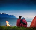
You will explore Nepalese culture, heritage, wildlife, adventure with…


Our team is at your service to help you with your booking issues or answer any related questions
1-888-214-4856
Start planning your tailor-made holiday by contacting one of our specialists of Nepal
call our specialists on
1-888-214-4856
Written by our travel specialists, our brochures highlight the incredible places you can explore and help simplify the choices when planning your trip. Whether you’re ready to enquire or just gathering ideas, we’re here to support you.
Our customers praise our staff’s professionalism and the world-class service we consistently provide.
ATOL and ABOT protected company. Plus, a refund within 14 days if your holiday is cancelled.
Our specialists have in-depth knowledge from extensive travel or living in the regions they manage.
Our prices are unmatched. Find a better deal, and we’ll refund the difference within 24 hours.
 Nepal
Nepal Singapore
 Taiwan
 India
India Bhutan
 Tibet
Tibet China
China Sri Lanka
 Thailand
 Cambodia
 Vietnam
 Laos
Laos Japan
Japan South Korea
 Maldives
 Malaysia
 Indonesia
 Philippines
 Mongolia
 Uzbekistan
 Ethiopia
 Kenya
Kenya Madagascar
 Mauritius
 Morocco
 Namibia
 Rwanda
 South Africa
 Tanzania
 Tunisia
 Uganda
 Zimbabwe
 Egypt
Egypt Jordan
 Oman
Oman Saudi Arabia
 United Arab Emirates
 Armenia
 Bulgaria
 Croatia
 Cyprus
 Czech Republic
 France
 Greece
 Iceland
 Ireland
 Italy
Italy Malta
Malta Portugal
 Romania
 Slovenia
 Spain
Spain Turkey
 America
 Belize
 Canada
 Costa Rica
 Guatemala
 Mexico
 Panama
 Argentina
 Brazil
 Chile
Chile Colombia
 Ecuador
 Peru
Peru Australia
 French Polynesia
 New Zealand